Yongding River
| Yongding River | |
|---|---|
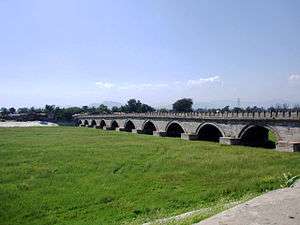 The Yongding River under the Marco Polo Bridge is dried out | |
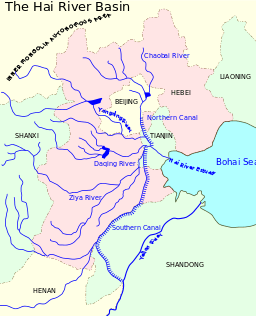 The Hai River Basin. | |
| Native name | 永定河 |
| Physical characteristics | |
| Main source |
Guancen Mountains Ningwu County, Shanxi Province |
| River mouth |
Hai River 39°09′44″N 117°10′34″E / 39.1623°N 117.1762°ECoordinates: 39°09′44″N 117°10′34″E / 39.1623°N 117.1762°E |
| Length | 650 kilometres (400 mi) |
| Basin features | |
| Basin size | 47,016 square kilometres (18,153 sq mi) |
| Bridges | Marco Polo Bridge |
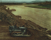
The Yongding River (Chinese: 永定河; pinyin: Yǒngdìng Hé; Wade–Giles: Yungting He) is a river in northern China. It is one of the main tributaries in the Hai River system and is best known as the largest river to flow through Beijing Municipality. In recent year, the Beijing segment of the river has dried up due to environmental issues.[1] Beijing Municipality government has invested 16 billion yuan in effort to replace the riverbed with parkland or smaller bodies of water.[2]
Etymology
The river was originally called Wuding River (simplified Chinese: 无定河; traditional Chinese: 無定河; pinyin: Wúdìng Hé), literally "indefinite river" due to the fact that its flow was irregular. When the Kangxi Emperor reigned, he enacted various hydraulic engineering projects in the region to rein in the seasonal flooding. After those projects, the river was renamed to its modern name, which means "ever-definite river". [3]
Geography
The Yongding River is 650 kilometres (400 mi) in length and drains an area of 47,016 square kilometres (18,153 sq mi). It emerges from the Guancen Mountains (管涔山) in Ningwu County, Shanxi Province, where it is known as the Cangqian River (桑乾河) and flows northeast into Inner Mongolia and then heads southeast into Hebei Province.
In Huailai County, it fills the Guanting Reservoir, the biggest reservoir serving Beijing and takes on the name Yongding. It enters Beijing Municipality through the Xishan Mountains west of the city in Mentougou District and descends into the flatlands of Fengtai and Daxing Districts.
The river eventually flows back into Hebei Province and then on to Tianjin Municipality, where it meets the Hai River just before the latter enters the city and then empties into the Bohai Sea at Tanggu. Part of the river is diverted before the juncture with the Hai, and flows directly into the Bohai Sea. This channel is called the Yongding New River (永定新河).
History
Historically, the river was notorious for its flash floods and course changes. The river has taken at least three major courses through Beijing. According to the earliest historical records, the river originally flowed northeast from Babaoshan toward what is now the Purple Bamboo Park in Haidian District and into Wenyu River.
- Western Han Dynasty
In the Western Han Dynasty, the river flowed south from Deshengmen through the present-day downtown Beijing, including Qianmen and Hongqiao and Longtan Lake, before leaving to the southeast. At that time, the city was situated to the southwest of today's city centre. In the Liao Dynasty, the river moved southwest to its present course, and the Lugou Bridge was built over it in 1189. When Marco Polo visited the city during the Yuan Dynasty, he crossed the Yongding River on the Lugou Bridge, which became known as the Marco Polo Bridge.
- Qing Dynasty
The river has been known colloquially as the Wuding River or the "River of Instability." In 1698, the Qing Dynasty Kangxi Emperor's government reinforced the river banks and rendered the current course permanent. Thereafter it became known as the Yongding River or the "River of Eternal Stability."[4]
Gallery
| Wikimedia Commons has media related to Yongding River. |
References
- ↑ Jiang, Bo; Wong, Christina P.; Lu, Fei; Ouyang, Zhiyun; Wang, Yajuan (2014). "Drivers of drying on the Yongding River in Beijing". Journal of Hydrology. 519: 69–79. Bibcode:2014JHyd..519...69J. doi:10.1016/j.jhydrol.2014.06.033.
- ↑ Hancock, Tom (2011-09-22). "Slideshow: reviving the Yongding". Chinadialogue.net. Chinadialogue.net. Retrieved 2017-01-29.
Beijing's government is spending 16 billion yuan (US$2.5 billion) on restoring the dried-out riverbed, filling it with water and creating parkland along the riverside.
- ↑ 小溪 (2009-11-29). "康熙与南惠济庙". china.com.cn (in Chinese). Beijing Daily. Retrieved 2018-03-07.
永定河之称谓始于康熙朝。康熙皇帝勤政,为人所共知;康熙皇帝大力治理浑河,将“无定河”改名为“永定河”,亦见诸史册。
- ↑ Li, Lillian M. (2007). Fighting Famine in North China: State, Market, and Environmental Decline, 1690s-1990s. Stanford University Press. pp. 41–43. ISBN 0-8047-5304-0.