Parlung Tsangpo
| Parlung Tsangpo (ཕར་ལུང་གཙང་པོ) (帕隆藏布) | |
| River | |
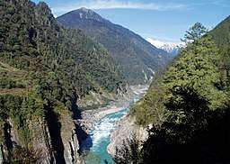 Parlung Tsangpo, just below the confluence of the tributary, Lhayue Chu (拉月曲), followed by China National Highway 318 | |
| Country | China |
|---|---|
| State | Tibet |
| Region | Nyingchi Prefecture |
| Part of | Yarlung Tsangpo |
| Mouth | |
| - coordinates | 29°52′35″N 95°7′23″E / 29.87639°N 95.12306°ECoordinates: 29°52′35″N 95°7′23″E / 29.87639°N 95.12306°E |
| Length | 266 km (165 mi) |
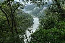
Parlung Tsangpo in Bomê.
Parlung Tsangpo (Tibetan: ཕར་ལུང་གཙང་པོ, Wylie: phar lung gtsang po ; Chinese: 帕隆藏布; pinyin: Pàlóng Zàngbù), is a river in Nyingchi, Tibet, China. It is the largest tributary on the left side of Yarlung Tsangpo. Its source is the Arza Gongla Glacier, at an elevation of 4900m. It first flow north into Ngagung Tso, then turn northwest to Rakwa Tso. It joins Yarlung Tsangpo near Bomê. The total length is 266 km, and the drop of elevation is 3360m. The drainage basin covers an area of 28,600 km2. The lower part of Parlung flows through the Parlung Tsangpo Valley, which is among the deepest in the world.
This article is issued from
Wikipedia.
The text is licensed under Creative Commons - Attribution - Sharealike.
Additional terms may apply for the media files.