Han River (Guangdong)
| Han River (韩江) | |
| Hán Jiāng | |
| River | |
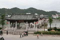
 Looking across the Han River from Chaozhou City. | |
| Country | China |
|---|---|
| States | Guangdong, Fujian, Jiangxi |
| Tributaries | |
| - left | Wuhua River, Ning River, Shiku River |
| - right | Ting River, Meitan River |
| Cities | Meizhou, Chaozhou, Shantou |
| Source | Mount Qixingdong (Mei River) |
| - location | Zijin County, Guangdong |
| Mouth | South China Sea |
| - location | Shantou, Guangdong |
| - elevation | 0 m (0 ft) |
| Length | 410 km (255 mi) [1] |
| Basin | 30,112 km2 (11,626 sq mi) [1] |
| Discharge | |
| - average | 870 m3/s (30,724 cu ft/s) [1] |
| - max | 13,300 m3/s (469,685 cu ft/s) [1] |
| - min | 33 m3/s (1,165 cu ft/s) [1] |
The Han River (simplified Chinese: 韩江; traditional Chinese: 韓江; pinyin: Hán Jiāng) is a river in southeast China. It is located mainly in eastern Guangdong province and has a total length of 410 kilometres (250 mi). The river is combined with two main tributary rivers, Mei River and Ting River, at Sanheba (三河坝), Dabu County.[2] Han River flows south through the Han River Delta entering the South China Sea at Chenghai District and Longhu District of Shantou.[1] The Teochew people refer to the river as "the Mother River".[3]
The river is named after Han Yu, a writer, poet and government official of the Tang dynasty, in honor of his contribution to Chaoshan.[4] It was originally named as E Xi (simplified Chinese: 恶溪; traditional Chinese: 惡溪; literally: "ferocious river") before Han Yu's exile to Chaozhou. The river became pacific under Han's river regulation and named after him after his departure.[5]
Gallery

References
Coordinates: 24°03′02″N 116°31′58″E / 24.05054°N 116.532669°E