Wei River
The Wei River (Chinese: 渭河; pinyin: Wèi Hé; Wade–Giles: Wei Ho) is a major river in west-central China's Gansu and Shaanxi provinces. It is the largest tributary of the Yellow River and very important in the early development of Chinese civilization.[1]
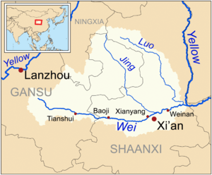
The source of the Wei River is close to Weiyuan County – Wei yuan meaning "Wei's source" – in Gansu province, less than 200 kilometres (120 mi) from the Yellow River at Lanzhou. However, due to the sharp turn north the Yellow River takes in Lanzhou, the Wei and the Yellow River do not meet for more than 2,000 kilometres (1,200 mi) further along the Yellow River's course. In a direct line, the Wei's source lies 700 kilometres (430 mi) west of the main city along its course, Xi'an in Shaanxi province. The length of the river is 818 kilometres (508 mi) and the area drained covers 135,000 square kilometres (52,000 sq mi).
The Wei River's tributaries include the Luo River, Jing River, Niutou River, Feng River and the Chishui River.
History

In Chinese mythology, the giant Kua Fu drained the Yellow River and the Wei River to quench his burning thirst as he pursued the Sun.[2] The valley of the Wei was one of the early cradles of Chinese civilization, along which the capitals of the Zhou, Qin, Han, and Tang Dynasties were situated. The area of Dingxi around its headwaters in Gansu has numerous stone age sites from various early cultures. The Wei Valley is likely the earliest center of Chinese civilization, and also the location of China's first major irrigation works.[3] Some Chinese historians now believe the Wei is the ancient Jiang River that gave its name to the families of Shennong and the Yan emperor, two Chinese legendary heroes credited with the early development of agriculture there.[4]
The headwaters of the Wei River are also notable in the development of the Northern Silk Road. The Chinese segment of the Northern Silk Road connected Xi'an (then the capital of China) to the west via Baoji, Tianshui at the Wei's headwaters, Lanzhou, Dunhuang, and the Wushao Ling Mountain, before looping north of the Takla Makan on its way to Kashgar and the routes into Parthia.[5]
In September 2003 extensive rainfall led to flooding that caused over 30 fatalities, and temporarily displaced over 300,000 persons.[6] Ecological aspects of the Wei River have been examined with respect to flow rates in the Wei River.[7]
The Wei River Bridge (Weihe qiao 渭河桥) featured in the design of the People's Bank of China 5000-yuan note, dated 1953, and shows a train passing over the bridge.[8]
References
- ↑ "Wei-River Gansu". Wei-River-Gansu-and-Shaanxi-provinces-China.
- ↑ Summary of the story given in the definition of 夸父追日 现代汉语词典(第七版). A Dictionary of Current Chinese (Seventh Edition). 北京. Beijing: 商务印书馆. The Commercial Press. 1 September 2016. pp. 513, 755. ISBN 978-7-100-12450-8.
- ↑ Encyclopædia Britannica Online Concise
- ↑ Pulleybank, Edwin G. "Ji 姬 and Jiang 姜: The Role of Exogamic Clans in the Organization of the Zhou Polity" (PDF). Early China, 25. 2000.
- ↑ C.Michael Hogan, Silk Road, North China, The Megalithic Portal, ed. Andy Burnham
- ↑ "17,000 Houses Collapse, 200,000 Evacuated in Flood-Hit China, Agence France-Presse 2 sept 03". Archived from the original on 2006-02-10. Retrieved 2006-03-21.
- ↑ J.X Song, Z.X. Xu, C.M. Liu, H.E. Li, Ecological and environmental instream flow requirements for the Wei River - the largest tributary of the Yellow River, 24 Jan. 2007
- ↑ First series of the renminbi#¥5,000
Coordinates: 34°36′42″N 110°17′20″E / 34.61167°N 110.28889°E