Yamato River
| Yamato River (大和川) | |
| Yamato-gawa | |
| first class river in Kansai region | |
 | |
| Country | Japan |
|---|---|
| Region | Kansai region |
| Source | |
| - location | Kaikira-yama, Nara Prefecture |
| - elevation | 822 m (2,697 ft) |
| Mouth | Osaka Bay |
| - coordinates | 34°36′30″N 135°26′28″E / 34.6084°N 135.4410°ECoordinates: 34°36′30″N 135°26′28″E / 34.6084°N 135.4410°E |
| Length | 68 km (42 mi) |
| Wikimedia Commons: Yamato River | |
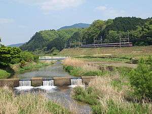
River in Sakurai, Nara Prefecture.
Yamato River (Yamatogawa) is a Japanese class A river in the Kansai region and flows via the Nara Prefecture and Osaka Prefecture to the Osaka Bay.
The river flows via towns:
Since 1704 the river was reconfigured, originally its flow was north from the Ishikawa River confluence point, where it joined the Shirinashi River and Kizu River. [1]
At the river mouth is a densely populated area and Yamatogawa forms a natural border between Osaka and Sakai cities. [2]
See also
| Wikimedia Commons has media related to Yamato River. |
References
- ↑ "Yamato River". Retrieved 28 March 2017.
- ↑ Davidson, Neil (4 January 2014). "Yamato River, Osaka". Retrieved 28 March 2017.
Article contains translated text from 大和川 on the Japanese Wikipedia retrieved on 26 March 2017.
| |||||||||||||||||
| |||||||||||||||||
| |||||||||||||||||
| |||||||||||||||||
| |||||||||||||||||
This article is issued from
Wikipedia.
The text is licensed under Creative Commons - Attribution - Sharealike.
Additional terms may apply for the media files.