Takahashi River
| Takahashi River | |
|---|---|
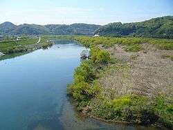 Takahashi River near Kiyone Station in Okayama Prefecture | |
| Country | Japan |
| Physical characteristics | |
| Main source |
Okayama Prefecture, with tributaries in Hiroshima Prefecture 1,188 m (3,898 ft) |
| River mouth |
Inland Sea 0 m (0 ft) |
| Length | 111 km (69 mi) |
| Discharge |
|
| Basin features | |
| Basin size | 2,670 km2 (1,031 sq mi) |
The Takahashi River (高梁川 Takahashi-gawa) is a Class A[1] major river[2] in the western part of Okayama Prefecture. It acts as the main drainage for the Takahashi River Drainage System, and is one of the three main drainage rivers in Okayama Prefecture (the others being the Yoshii River and the Asahi River).
Description
The Takahashi River originates from Akechi Pass near Hanamiyama in Tottori Prefecture, 1,188 m (3,898 ft) above sea level. It flows through the cities of Niimi, Takahashi, Sōja, and Kurashiki, eventually flowing into the Mizushimanada area of the Inland Sea. The mouth is located between the Mizushima and Tamashima areas of Kurashiki. Reconstruction and repairs in 1907 created the eastern and western branches of the Takahashi River.
Major tributaries
- Nariwa River (成羽川 Nariwa-gawa): Flows from the northeast area of Hiroshima Prefecture to the western part of Okayama Prefecture.
References
- ↑ "河川法第四条第一項の水系を指定する政令" [River Law Clause 4 Paragraph 1: River System Designation Ordinance] (in Japanese). e-Gov.go.jp. Archived from the original on July 6, 2016. Retrieved July 6, 2016.
- ↑ Oya, Masahiko (January 15, 2014) [2001]. Applied Geomorphology for Mitigation of Natural Hazards. Springer Science+Business Media. doi:10.1007/978-94-010-0961-4. ISBN 978-94-010-3804-1.
| |||||||||||||||||
| |||||||||||||||||
| |||||||||||||||||
| |||||||||||||||||
| |||||||||||||||||
This article is issued from
Wikipedia.
The text is licensed under Creative Commons - Attribution - Sharealike.
Additional terms may apply for the media files.