Shōnai River
| Shōnai River 庄内川 | |
|---|---|
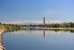 The Scene Johoku and Shōnai River bridge | |
| Country | Japan |
| Physical characteristics | |
| Main source |
Mount Yūdachi 727 m (2,385 ft) |
| River mouth | Ise Bay |
| Length | 96 km (60 mi) |
| Discharge |
|
| Basin features | |
| River system | Shōnai River |
| Basin size | 1,010 km2 (390 sq mi) |
The Shōnai River (庄内川 Shōnai-gawa) is a Class 1 river flowing through Gifu and Aichi prefectures in Japan. In Gifu Prefecture, it is also referred to as the Toki River (土岐川 Toki-gawa); around the city of Kasugai in Aichi Prefecture, it is referred to as the Tamano River (玉野川 Tamano-gawa). Fujimae-higata (designated sites as List of Ramsar wetlands of international importance) exists in the River mouth.
Geography
The river originates at Mount Yūdachi in Ena, Gifu Prefecture. After flowing through the Tamano Valley in Aichi Prefecture, it enters the Nōbi Plain, before emptying into Ise Bay through Nagoya's Minato-ku.
River communities
The river passes through or forms the boundary of the communities listed below.
References
External links
| Wikimedia Commons has media related to Shōnai River. |
35°01′56″N 136°50′34″E / 35.032218°N 136.842667°ECoordinates: 35°01′56″N 136°50′34″E / 35.032218°N 136.842667°E (mouth)
| |||||||||||||||||
| |||||||||||||||||
| |||||||||||||||||
| |||||||||||||||||
| |||||||||||||||||