Yasu River
| Yasu River | |
|---|---|
 | |
| Native name | 野洲川 |
| Country | Japan |
| Physical characteristics | |
| Main source | Suzuka Mountains |
| River mouth | Lake Biwa |
| Length | 65.25 km (40.54 mi) |
| Basin features | |
| River system | Yodo River |
| Basin size | 387 km2 (149 sq mi) |
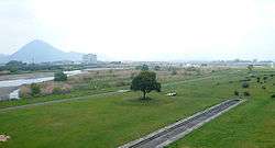
The Yasu River (野洲川 Yasu-gawa) is located in Shiga Prefecture, Japan; it is the largest river to flow into Lake Biwa. It rises from Mount Gozaisho and flows through Kōka, Konan, Rittō, Moriyama and Yasu. It forked at the lower reaches and made a delta region, but they were combined in 1979.
History
The Tōkaidō, one of the Edo Five Routes which connected east and west Japan during the Edo period, paralleled the river. Post towns along the river included Tsuchiyama-juku, Minakuchi-juku and Ishibe-juku. The Yasu River also crossed the Nakasendō, another one of the Edo Five Routes, separating Moriyama-juku and Musa-juku.
References
External links
![]()
| |||||||||||||||||
| |||||||||||||||||
| |||||||||||||||||
| |||||||||||||||||
| |||||||||||||||||