Kashiwara, Osaka
| Kashiwara 柏原市 | |||
|---|---|---|---|
| City | |||
 View of Kashiwara | |||
| |||
 Location of Kashiwara in Osaka Prefecture | |||
 Kashiwara Location in Japan | |||
| Coordinates: 34°35′N 135°38′E / 34.583°N 135.633°ECoordinates: 34°35′N 135°38′E / 34.583°N 135.633°E | |||
| Country | Japan | ||
| Region | Kansai | ||
| Prefecture | Osaka Prefecture | ||
| Area | |||
| • Total | 25.39 km2 (9.80 sq mi) | ||
| Population (October 1, 2016) | |||
| • Total | 76,383 | ||
| • Density | 3,000/km2 (7,800/sq mi) | ||
| Time zone | UTC+9 (JST) | ||
| Website |
www | ||


Kashiwara (柏原市 Kashiwara-shi) is a city located in Osaka Prefecture, Japan. The city was founded on October 1, 1958.
As of October 2016, the city has an estimated population of 76,383 and a population density of 3,000 persons per km². The total area is 25.39 km².
Location
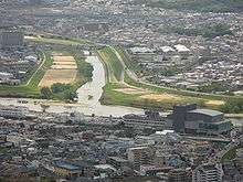
The city sits on the Yamato River in the east of Osaka Prefecture. Kashiwara sits along the Nara prefectural border and is separated from Nara Prefecture by the Kongo and Ikoma mountains. To the north and west is Yao city and to the south are Fujidera and Habikino cities. The Yao and southern Habikino borders are indistinct within the continuous settlement as with many cities in Osaka Prefecture. Kashiwara is separated from Fujidera by the Yamato River and the Ishi River.
History
Kashiwara City was originally one of many small towns and villages in the east of the Kawachi region. The formation of the modern city is relatively recent. Kashiwara Town absorbed Katashimo Town and Katakami Village in 1939. The large area of Kokubu Town merged with Kashiwara Town in 1956. In 1958, Kashiwara was recognised as an official city.[1] Kansai University of Welfare Sciences was established in the city in 1997.
Transportation
External links

- Kashiwara City official website (in Japanese)
- Kashiwara City official website (in English)
Notes
| Wards of Osaka | ||
|---|---|---|
| Wards of Sakai | ||
| Core cities | ||
| Special cities | ||
| Cities | ||
| Districts | ||
| Authority control |
|---|