Westerlo
| Westerlo | |||
|---|---|---|---|
| Municipality | |||
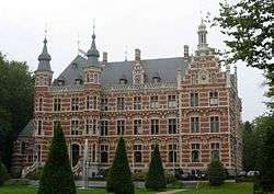 Town Hall of Westerlo | |||
| |||
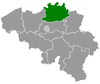
 Westerlo Location in Belgium
Westerlo municipality in the province of Antwerp 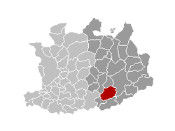 | |||
| Coordinates: 51°05′N 04°55′E / 51.083°N 4.917°ECoordinates: 51°05′N 04°55′E / 51.083°N 4.917°E | |||
| Country | Belgium | ||
| Community | Flemish Community | ||
| Region | Flemish Region | ||
| Province | Antwerp | ||
| Arrondissement | Turnhout | ||
| Government | |||
| • Mayor | Guy Van Hirtum (CD&V) | ||
| • Governing party/ies | CD&V | ||
| Area | |||
| • Total | 55.13 km2 (21.29 sq mi) | ||
| Population (1 January 2017)[1] | |||
| • Total | 24,688 | ||
| • Density | 450/km2 (1,200/sq mi) | ||
| Postal codes | 2260 | ||
| Area codes | 014 - 015 - 016 | ||
| Website | www.westerlo.be | ||

Westerlo (Dutch pronunciation: [ˈʋɛstərloː]) is a municipality located in the Belgian province of Antwerp. The municipality comprises seven towns:
- Westerlo centrum (population 3,831)
- Oevel (population 3,454)
- Tongerlo (population 4,679)
- Heultje (population 3,973)
- Voortkapel (population 2,408)
- Oosterwijk (population 2,350)
- Zoerle-Parwijs (population 2,202)
On January 1, 2006 Westerlo had a total population of 22,896. The total area is 55.13 km² which gives a population density of 415 inhabitants per km².
Places of interest
Tongerlo Abbey contains a very old and fine copy of Leonardo da Vinci's The Last Supper. It is also known as home of the Tongerlo Abbey beer, but this is no longer brewed at the abbey.
Gallery
 Westerlo, townhall
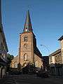 Westerlo, church
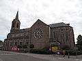 Tongerlo, church
 Oevel, church
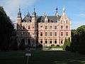
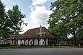 Hof van Overwijs
See also
References
- ↑ Population per municipality as of 1 January 2017 (XLS; 397 KB)
External links

- Official website (in Dutch)
| Authority control |
|---|
This article is issued from
Wikipedia.
The text is licensed under Creative Commons - Attribution - Sharealike.
Additional terms may apply for the media files.