Berlaar
| Berlaar | |||
|---|---|---|---|
| Municipality | |||
| |||
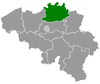
 Berlaar Location in Belgium
Location of Berlaar in the province of Antwerp 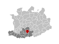 | |||
| Coordinates: 51°07′N 04°39′E / 51.117°N 4.650°ECoordinates: 51°07′N 04°39′E / 51.117°N 4.650°E | |||
| Country | Belgium | ||
| Community | Flemish Community | ||
| Region | Flemish Region | ||
| Province | Antwerp | ||
| Arrondissement | Mechelen | ||
| Government | |||
| • Mayor | Walter Horemans (CD&V) | ||
| • Governing party/ies | CD&V, N-VA | ||
| Area | |||
| • Total | 24.57 km2 (9.49 sq mi) | ||
| Population (1 January 2017)[1] | |||
| • Total | 11,385 | ||
| • Density | 460/km2 (1,200/sq mi) | ||
| Postal codes | 2590 | ||
| Area codes | 03, 015 | ||
| Website | www.berlaar.be | ||


Berlaar (Dutch pronunciation: [ˈbɛrlaːr]) is a municipality located in the Belgian province of Antwerp. The municipality comprises the towns of Berlaar proper and Gestel. On January 1, 2011, Berlaar had a total population of 10,891. The total area is 24.57 km² which gives a population density of 443 inhabitants per km².
History
The current municipality of Berlaar was founded on 1 January 1965. Berlaar is actually a fusion of the former municipality Gestel and the Core of Berlaar itself. Berlaar is a part of the Belgische Kempen.
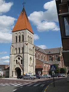
According to legend, the citizens of the early Middle Ages couldn't agree on where the church had to be built. They let fate decide and let two bears fight over it. Where the one bear killed the other, that would be the location the church should be built. Hence the exceptional position of the church at the end of the village square and not in the center as usual.[2]
References
External links

- Official website (Dutch only)
Places adjacent to Berlaar | ||||||||||
|---|---|---|---|---|---|---|---|---|---|---|
| ||||||||||