Putte
| Putte | |||
|---|---|---|---|
| Municipality | |||
| |||
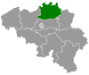
 Putte Location in Belgium
Location of Putte in the province of Antwerp 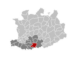 | |||
| Coordinates: 51°03′N 04°38′E / 51.050°N 4.633°ECoordinates: 51°03′N 04°38′E / 51.050°N 4.633°E | |||
| Country | Belgium | ||
| Community | Flemish Community | ||
| Region | Flemish Region | ||
| Province | Antwerp | ||
| Arrondissement | Mechelen | ||
| Government | |||
| • Mayor | Chris De Veuster (CD&V) | ||
| • Governing party/ies | CD&V, N-VA | ||
| Area | |||
| • Total | 34.96 km2 (13.50 sq mi) | ||
| Population (1 January 2017)[1] | |||
| • Total | 17,379 | ||
| • Density | 500/km2 (1,300/sq mi) | ||
| Postal codes | 2580 | ||
| Area codes | 015, 03 | ||
| Website | www.putte.be | ||


Putte (Dutch pronunciation: [ˈpɵtə]) is a municipality located in the Belgian province of Antwerp. The municipality comprises the towns of Putte, Beerzel, Grasheide and Peulis. The town of Putte is around 8 kilometres (5.0 mi) east of Mechelen. On January 1, 2018 Putte had a total population of 17,584. The total area is 34.96 km² which gives a population density of 503 inhabitants per km².
The Beerzelberg (51.60 m), which is the highest point of the Antwerp province, is located in Beerzel.
Putte should not be confused with Putte in the Kempen, split by the border into Putte, Netherlands and Putte, Kapellen.
References
- ↑ Population per municipality as of 1 January 2017 (XLS; 397 KB)
External links

- Official website - Available only in Dutch
Places adjacent to Putte | |
|---|---|
This article is issued from
Wikipedia.
The text is licensed under Creative Commons - Attribution - Sharealike.
Additional terms may apply for the media files.