Aartselaar
| Aartselaar | |||
|---|---|---|---|
| Municipality | |||
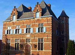 Aartselaar town hall | |||
| |||
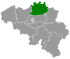
 Aartselaar Location in Belgium
Location of Aartselaar in the province of Antwerp  | |||
| Coordinates: 51°08′N 04°23′E / 51.133°N 4.383°ECoordinates: 51°08′N 04°23′E / 51.133°N 4.383°E | |||
| Country | Belgium | ||
| Community | Flemish Community | ||
| Region | Flemish Region | ||
| Province | Antwerp | ||
| Arrondissement | Antwerp | ||
| Government | |||
| • Mayor | Sophie De Wit (N-VA) | ||
| • Governing party/ies | N-VA, sp.a-Groen | ||
| Area | |||
| • Total | 10.93 km2 (4.22 sq mi) | ||
| Population (1 January 2017)[1] | |||
| • Total | 14,222 | ||
| • Density | 1,300/km2 (3,400/sq mi) | ||
| Postal codes | 2630 | ||
| Area codes | 03 | ||
| Website | www.aartselaar.be | ||

Aartselaar (Dutch pronunciation: [ˈaːrtsəlaːr], old spelling: Aertselaer) is a municipality located in the Belgian province of Antwerp. The municipality only comprises the town of Aartselaar proper. On January 1, 2006 Aartselaar had a total population of 14,375. The total area is 10.93 km² which gives a population density of 1,316 inhabitants per km². The municipality of Aartselaar is located in the southern outskirts of Antwerp. It is known for its 1801 windmill (Heimolen) as well as the cycling race called Memorial Rik Van Steenbergen.
Etymology
The origin of the name of the town is obscure; the most probable etymology refers to "Arcelar", a clearing in the woods (laar) located near a border (archas).[2]
References
External links

This article is issued from
Wikipedia.
The text is licensed under Creative Commons - Attribution - Sharealike.
Additional terms may apply for the media files.