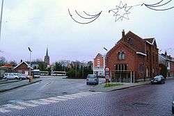
Rumst
| Rumst | |||
|---|---|---|---|
| Municipality | |||
 | |||
| |||
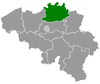
 Rumst Location in Belgium
Location of Rumst in the province of Antwerp 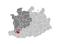 | |||
| Coordinates: 51°05′N 04°25′E / 51.083°N 4.417°ECoordinates: 51°05′N 04°25′E / 51.083°N 4.417°E | |||
| Country | Belgium | ||
| Community | Flemish Community | ||
| Region | Flemish Region | ||
| Province | Antwerp | ||
| Arrondissement | Antwerp | ||
| Government | |||
| • Mayor | Geert Antonio (N-VA) | ||
| • Governing party/ies | N-VA, CD&V | ||
| Area | |||
| • Total | 19.90 km2 (7.68 sq mi) | ||
| Population (1 January 2017)[1] | |||
| • Total | 15,083 | ||
| • Density | 760/km2 (2,000/sq mi) | ||
| Postal codes | 2840 | ||
| Area codes | 03, 015 | ||
| Website | www.rumst.be | ||


Rumst (Dutch pronunciation: [rʏmst], old spelling: Rumpst) is a municipality located in the Belgian province of Antwerp. Since 1976 the municipality not only comprises Rumst proper but also the towns of Reet (old spelling: Reeth) and Terhagen, which were independent municipalities before that year.
Industry in Rumst, like Boom, was heavily focused around the production of clay products like bricks. This industry has largely disappeared after 1970.
In Rumst, the river Rupel starts as a combination of the Dijle and Nete (river) rivers.
On January 1, 2006, Rumst had a total population of 14,628. The total area is 19.90 km² which gives a population density of 735 inhabitants per km².
Notable residents
- Kristof Calvo, Belgian politician, was born in Rumst
- Yvonne Verbeeck, actress
References
- ↑ Population per municipality as of 1 January 2017 (XLS; 397 KB)
External links

- (in Dutch) Official website
Places adjacent to Rumst | |
|---|---|
This article is issued from
Wikipedia.
The text is licensed under Creative Commons - Attribution - Sharealike.
Additional terms may apply for the media files.