Stabroek
- Georgetown, Guyana was known as Stabroek prior to 1812.
| Stabroek | |||
|---|---|---|---|
| Municipality | |||
 | |||
| |||
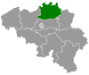
 Stabroek Location in Belgium
Location of Stabroek in the province of Antwerp  | |||
| Coordinates: 51°20′N 04°22′E / 51.333°N 4.367°ECoordinates: 51°20′N 04°22′E / 51.333°N 4.367°E | |||
| Country | Belgium | ||
| Community | Flemish Community | ||
| Region | Flemish Region | ||
| Province | Antwerp | ||
| Arrondissement | Antwerp | ||
| Government | |||
| • Mayor | Rik Frans (N-VA) | ||
| • Governing party/ies | N-VA, CD&V | ||
| Area | |||
| • Total | 21.51 km2 (8.31 sq mi) | ||
| Population (1 January 2017)[1] | |||
| • Total | 18,498 | ||
| • Density | 860/km2 (2,200/sq mi) | ||
| Postal codes | 2940 | ||
| Area codes | 03 | ||
| Website | www.stabroek.be | ||


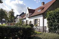
Stabroek (Dutch pronunciation: [ˈstaːbruk]) is a municipality located in the Belgian province of Antwerp. The municipality comprises the towns of Hoevenen and Stabroek proper. On December 31, 2006 Stabroek had a total population of 17,618. The total area is 21.51 km² which gives a population density of 818 inhabitants per km². In 2008 Stabroek celebrated its 750-year-old existence.
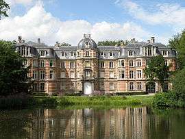
Ravenhof castle in Stabroek-Putte
Famous inhabitants
- Thomas Vermaelen, football player currently playing for AS Roma
References
- ↑ Population per municipality as of 1 January 2017 (XLS; 397 KB)
External links

- (in Dutch) Official website
- (in Dutch) Official website for the 750-year anniversary
This article is issued from
Wikipedia.
The text is licensed under Creative Commons - Attribution - Sharealike.
Additional terms may apply for the media files.