Sint-Amands
| Sint-Amands | |||
|---|---|---|---|
| Municipality | |||
 Sint-Amands town hall | |||
| |||
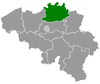
 Sint-Amands Location in Belgium
Location of Sint-Amands in the province of Antwerp 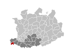 | |||
| Coordinates: 51°03′N 04°12′E / 51.050°N 4.200°ECoordinates: 51°03′N 04°12′E / 51.050°N 4.200°E | |||
| Country | Belgium | ||
| Community | Flemish Community | ||
| Region | Flemish Region | ||
| Province | Antwerp | ||
| Arrondissement | Mechelen | ||
| Government | |||
| • Mayor | Peter Van Hoeymissen (CD&V) | ||
| • Governing party/ies | CD&V | ||
| Area | |||
| • Total | 15.58 km2 (6.02 sq mi) | ||
| Population (1 January 2017)[1] | |||
| • Total | 8,418 | ||
| • Density | 540/km2 (1,400/sq mi) | ||
| Postal codes | 2890 | ||
| Area codes | 052, 03 | ||
| Website | www.sint-amands.be | ||


Sint-Amands (Dutch pronunciation: [ˌsɪnt ɑˈmɑnts]) is a municipality located in the Belgian province of Antwerp, Belgium. The municipality comprises the towns of Lippelo, Oppuurs and Sint-Amands proper. On January 1, 2006 Sint-Amands had a total population of 7,781. The total area is 15.58 km² which gives a population density of 500 inhabitants per km². Sint-Amands is located at the right bank of the Scheldt river.
Effective 1 January 2019, Puurs and Sint-Amands will be merged into the new municipality of Puurs-Sint-Amands.
Born in Sint-Amands
- Emile Verhaeren, poet (1855-1916). He died through a train accident in Rouen (France) on November 27th 1916. His grave is located on the bank of the Scheldt river.
See also
References
- ↑ Population per municipality as of 1 January 2017 (XLS; 397 KB)
External links

- Official website - Information available in Dutch and limited information in French
Places adjacent to Sint-Amands | ||||||||||
|---|---|---|---|---|---|---|---|---|---|---|
| ||||||||||
This article is issued from
Wikipedia.
The text is licensed under Creative Commons - Attribution - Sharealike.
Additional terms may apply for the media files.