Billingshurst
| Billingshurst | |
|---|---|
 | |
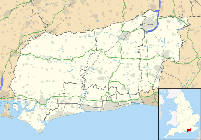 Billingshurst Billingshurst shown within West Sussex | |
| Area | 32.19 km2 (12.43 sq mi) [1] |
| Population |
6,531 [1] 2001 Census 8,232 (2011 Census)[2] |
| • Density | 203/km2 (530/sq mi) |
| OS grid reference | TQ087259 |
| • London | 36 miles (58 km) NNE |
| Civil parish |
|
| District | |
| Shire county | |
| Region | |
| Country | England |
| Sovereign state | United Kingdom |
| Post town | BILLINGSHURST |
| Postcode district | RH14 |
| Dialling code | 01403 |
| Police | Sussex |
| Fire | West Sussex |
| Ambulance | South East Coast |
| EU Parliament | South East England |
| UK Parliament | |
| Website | http://www.billingshurst.gov.uk/ |
Billingshurst is a village and civil parish in the Horsham District of West Sussex, England. The village lies 8 miles (13 km) south-west of Horsham, and 5.6 miles (9 km) north-east of Pulborough.
Billingshurst is located on the A29 road (the Roman Stane Street), at a point where the A272 road forms a crossroads with it. The civil parish has a land area of 7,952 acres (3,219 hectares). In the 2001 census 6,531 people lived in 2,677 households, of whom 3,451 were economically active. At the 2011 Census the population had increased to 8,232.[2]
The village's name probably came from Anglo-Saxon Billinges hyrst = "Billa's son's wooded hill".[3]
Community facilities

The village has a secondary school and a sixth form college, known together as The Weald School. Billingshurst Primary School (formerly two separate infant and junior schools, until a decision was taken in 2009 and implemented in 2010 to combine them into one) is situated near to The Weald. In 2017, construction finished on a newly built building (E Block) featuring Maths rooms, Art rooms, Computer rooms and the schools new main canteen on the lower floor.
The Weald School site contains a leisure centre with swimming pool and gym which is open to the public. A new sports area, Jubilee Fields, contains football pitches, two cricket pitches and pavilion, a fishing lake, and an exercise (trim trail) path. In the last year a new skatepark has also been added. Other facilities in the village include a tennis club and a lawn bowling club.
Transport
Billingshurst lies on the junction of the A29 and the A272 which are routes to Petworth, Petersfield, Haywards Heath, Pulborough and Bognor Regis.
Billingshurst railway station, located on Station Rd. in Billingshurst, is on the main line from London Victoria to Bognor Regis and Chichester. It would take about 20 minutes to get to Crawley by train.
The village is near the Wey and Arun Canal, which waterway has not been fully navigable since the 1890s.
Approximate travelling times by car from the larger towns and cities near Billingshurst are 35 minutes to Guildford, 30 minutes to Crawley and Chichester, 25 minutes to Haslemere and 35 minutes to Haywards Heath.
Religious sites
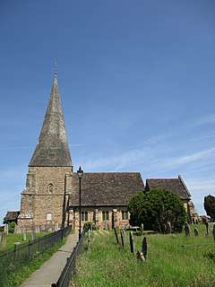
Billingshurst has four churches. St Mary's Church (Church of England) is the oldest, with a mix of service styles, ranging from Book of Common Prayer communion services to informal family worship. Other churches are St Gabriel's Church (Catholic), Billingshurst Family Church (Evangelical; part of the Commission family of churches) and Trinity Church (United Reformed). Billingshurst Unitarian Chapel, set back behind the High Street, was founded in 1754 and is one of southeast England's oldest Nonconformist places of worship.[4]
Football Team
Billingshurst Football Club was founded in 1981. The first team is currently in the second division of the Southern Combination Football League. The club's colours are red and black.
References
- 1 2 "2001 Census: West Sussex – Population by Parish" (PDF). West Sussex County Council. Archived from the original (PDF) on 8 June 2011. Retrieved 12 April 2009.
- 1 2 "Civil Parish population 2011". Neighbourhood Statistics. Office for National Statistics. Retrieved 26 September 2016.
- ↑ "Billingshurst Family Crest, Coat of Arms and Name History". www.houseofnames.com. Retrieved 2015-10-05.
- ↑ Lines, Wendy (1995). Billingshurst. The Archive Photographs Series. Chalford: Chalford Publishing Company. p. 87. ISBN 0-7524-0301-X.
External links
| Wikimedia Commons has media related to Billingshurst. |