Rural City of Wangaratta
| Rural City of Wangaratta Victoria | |||||||||||||||
|---|---|---|---|---|---|---|---|---|---|---|---|---|---|---|---|
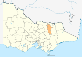 Location in Victoria | |||||||||||||||
| Population | 28,310 (2016 census)[1] | ||||||||||||||
| • Density | 7.7796/km2 (20.149/sq mi) | ||||||||||||||
| Established | 1994 | ||||||||||||||
| Gazetted | 18 November 1994[2] | ||||||||||||||
| Area | 3,639 km2 (1,405.0 sq mi) | ||||||||||||||
| Mayor | Ken Clarke OAM | ||||||||||||||
| Council seat | Wangaratta | ||||||||||||||
| Region | Hume | ||||||||||||||
| State electorate(s) | Ovens Valley | ||||||||||||||
| Federal Division(s) | Indi | ||||||||||||||
|
| |||||||||||||||
| Website | Rural City of Wangaratta | ||||||||||||||
| |||||||||||||||
The Rural City of Wangaratta is a local government area in the Hume region of Victoria, Australia, located in the north-east part of the state. It covers an area of 3,639 square kilometres (1,405 sq mi) and, at the 2016 Census, had a population of 28,310.[1] It includes the towns of Cheshunt, Eldorado, Everton, Glenrowan, Greta, Greta West, Milawa, Moyhu, Oxley, Tarrawingee, Wangaratta and Whitfield. It was formed in 1994 from the amalgamation of the City of Wangaratta, Shire of Wangaratta, Shire of Oxley, and parts of the United Shire of Beechworth, Shire of Benalla and Shire of Yarrawonga. When formed the municipality was originally called the Shire of Milawa, but a few months later, was renamed to its current name.[2]
The Rural City is governed and administered by the Wangaratta Rural City Council; its seat of local government and administrative centre is located at the council headquarters in Wangaratta. The Rural City is named after the main urban settlement located in the north of the LGA, that is Wangaratta, which is also the LGA's most populous urban centre with a population of around 18,500.[3]
Council
Current composition
The council is composed of three wards and seven councillors, with four councillors elected to the City Ward and one councillor per remaining ward elected to represent each of the other wards.[4] As of October 2016, the residents of the municipality had elected 7 new councillors:
| Ward | Councillor | Notes | |
|---|---|---|---|
| City | Ruth Amery (dec. 2017) | Cr Ashlee Fitzpatrick elected via countback | |
| Ken Clarke | Mayor (2017–18) | ||
| Dave Fuller | |||
| Dean Rees | |||
| North | Harvey Benton | ||
| South | Harry Bussell | ||
| Warby | Mark Currie | ||
History
The election of Councillors in 2016 followed a three year period where the Council was governed by Administrators. Administrators had been appointed by an Act of Parliament, following the dismissal of the Councillors elected at the 2012 general election. [5] A panel of three administrators, by an Act of Parliament, was appointed to oversee the council until the 2016 municipal elections.[6][7]
Administration and governance
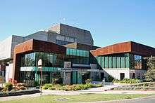
The councillors meet in the council chambers at the council headquarters in the Wangaratta Government Centre, which is also the location of the council's administrative activities. It also provides customer services at its administrative centre in Wangaratta.
See also
References
- 1 2 Australian Bureau of Statistics (27 June 2017). "Wangaratta (RC)". 2016 Census QuickStats. Retrieved 15 November 2017.

- 1 2 Victoria Government Gazette – Online Archive (1837–1997). "S87 of 1994: Order estg (Part 5) the Shire of Milawa". State Library of Victoria. State Government of Victoria (published 18 November 1994). p. 3. Retrieved 10 January 2014.
- ↑ Census QuickStats (2016). "Wangaratta (UCL) – UCL213017". Australian Bureau of Statistics. Government of Australia. Retrieved 10 December 2017.
- ↑ Local Government in Victoria. "Wangaratta Rural City Council". Department of Transport, Planning and Local Infrastructure. State Government of Victoria. Retrieved 10 January 2014.
- ↑ "Wangaratta Council to be dismissed". Premier of Victoria. 18 September 2013. Retrieved 21 December 2013.
- ↑ Parliament of Victoria (2013). "Local Government (Rural City of Wangaratta) Act 2013". Australasian Legal Information Institute. Retrieved 20 December 2013.
- ↑ Wangaratta Rural City Council (2013). "About Council – Councillors". Rural City of Wangaratta. Retrieved 20 December 2013.
External links
- Wangaratta Rural City Council official website
- Metlink local public transport map
- Link to Land Victoria interactive maps
Coordinates: 36°21′21″S 146°19′33″E / 36.35583°S 146.32583°E