Cobham Bridge
| Cobham Bridge | |
|---|---|
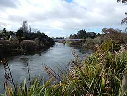 Cobham Bridge in 2016 (after 2015 repaint) | |
| Carries | Motor vehicles, bicycles, pedestrians |
| Crosses | Waikato River |
| Owner | NZTA |
| Preceded by | Narrows Bridge |
| Followed by | Victoria Bridge, Hamilton |
| Characteristics | |
| Total length | 143.3m |
| Width | 9.14m |
| No. of spans | four – 33.5m, 39.6m, 30.5m |
| History | |
| Opened | 1963 |
| Statistics | |
| Daily traffic | ADT 2010: 27,606 ADT 2011: 26,600 ADT 2012: 26,214 ADT 2013: 28,249 ADT 2014: 27,510[1] |
Cobham Bridge is a 143.3 m (470 ft) long[2] girder bridge[3] in Hamilton, New Zealand, on Cobham Drive, which is part of SH1.
It spans the Waikato River and was opened in 1963. Its deck is 28 m (92 ft) above sea level.[2] The river bed is 3.5 m (11 ft) above sea level.[4]
Like the 1962 Cobham Bridge over the Whanganui River, it was opened when Lord Cobham was Governor General, though not opened by him. Mrs Adams-Schneider, Mayor Denis Rogers and Minister of Works, William Stanley Goosman, were at the opening.[5]
References
- ↑ Traffic Counts – Abley Transportation Consultants Ltd
- 1 2 Highways Information Sheet 01N-0554 (D)
- ↑ "Hamilton City River Plan". www.hamiltoncityriverplan.co.nz. Retrieved 26 June 2017.
- ↑ "Degradation of the Waikato River – Karapiro to Ngaruawahia – Review of Existing Knowledge & Recommendations for Future Work" (PDF). Environment Waikato. August 2003.
- ↑ "COBHAM BRIDGE OPENING". Triton | Stories. Retrieved 26 June 2017.
External links
Google Street Scene from the bridge
Aerial views –
Coordinates: 37°48′19.9″S 175°17′42.1″E / 37.805528°S 175.295028°E
This article is issued from
Wikipedia.
The text is licensed under Creative Commons - Attribution - Sharealike.
Additional terms may apply for the media files.