Whitiora Bridge
| Whitiora Bridge | |
|---|---|
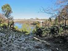 2012 view from riverside walkway | |
| Coordinates | 37°47′S 175°17′E / 37.78°S 175.28°ECoordinates: 37°47′S 175°17′E / 37.78°S 175.28°E |
| Carries | Motor vehicles |
| Crosses | Waikato River |
| Owner | Hamilton City Council |
| Preceded by | Claudelands Bridge |
| Followed by | Fairfield Bridge |
| Characteristics | |
| Total length | 260 metres (850 ft) |
| Height | 28 metres (92 ft) |
| No. of spans | 45, 53, 64, 53, 45 m |
| History | |
| Constructed by | Rope Construction Ltd |
| Construction start | 1975 |
| Construction end | 1978 |
| Statistics | |
| Daily traffic | 21,400 (2011), 25,200 (2015)[1] |
Whitiora Bridge is a prestressed concrete box girder bridge in Hamilton, New Zealand, spanning the Waikato River. It cost $2.35m, or $3.4m including the approach roads,[2] and was opened at the start of a weekend of Centennial celebrations,[3] on 11 February 1978, by representatives of Māori, Government and City, Dame Te Atairangikaahu, Venn Young and Ross Jansen.[4]
The 1969 Hamilton Transportation Study proposed the bridge,[5] which was designed by Murray North Partners (who also designed Pukete sewer bridge and Rangiriri bridge) and built by Rope Construction Ltd[4] (who also built Rakaia Bridge). It is on Taupo pumice alluvium[6] and carries Boundary Rd at a 25 degree skew over the river and River Rd. At 260m, that makes it significantly longer than 133m Claudelands, or 139m Fairfield, but the alignment minimised tree damage and lined up with a new extension of Boundary Rd from Mill St/Ulster St. The east end of Boundary Rd was shown on the 1879 map of Claudelands,[7] In 1915 there was a complaint about its lack of drainage[8] and, in 1933, Jesmond Park was laid out at its river end, later crossed by the bridge.[9]
The bridge rests on four 1.8m diameter octagonal piers, sunk 30m below the river,[10] which are slightly narrower than the 5 spans of box girders. Sliding hinge joints in the landward spans give earthquake protection. Hydraulic shock transmission at the expansion joints will keep the sections of the bridge together in an earthquake.[4]
Cycle Action Waikato complained in 2014, after the 2 traffic lanes, cycle tracks and footpath were converted to 3 traffic lanes and a footpath[11] in 2006.[12] The City's 1972 design brief, required up to 4 traffic lanes.[4] The bridge carries about 200 cyclists a day and a clip-on cycle lane has been considered.[12]
During its design and construction the bridge was known as the Boundary Road Bridge and is still often referred to as such.[13] 'Whitiora' was selected from a public suggestion, derived from 'Whiti', the call of the pipiwharauroa, and 'ora', meaning life, or health.[14]
Miropiko pā, beside River Rd, just south of the bridge, is the best preserved of a number of Hamilton pā sites.[15]
References
- ↑ Hamilton City Council Traffic Counting Data
- ↑ "Centenary celebrations : 100 years of local government 1878–1978". Hamilton. Retrieved 5 July 2017.
- ↑ "Centenary celebrations : 100 years of local government 1878–1978". Hamilton. Retrieved 5 July 2017.
- 1 2 3 4 "Innovate NZTM Awards of Excellence, 1965 – 2015: 1978 – Whitiora Bridge, Hamilton by Murray-North Partners Limited" (PDF). Association of Consulting and Engineering Professionals in New Zealand (ACENZ). 2015.
- ↑ "Centenary celebrations : 100 years of local government 1878–1978". Hamilton. Retrieved 5 July 2017.
- ↑ EDBROOKE, S. W. "Geology of the Waikato Area 1:250 000 geological map 4". Institute of Geological & Nuclear Sciences.
- ↑ Collection, The New Zealand. "University of Waikato Library – Historical Maps Collection". digital.liby.waikato.ac.nz. Retrieved 16 June 2017.
- ↑ "CLAUDELANDS STREETS. (Waikato Times, 1915-07-26)". paperspast.natlib.govt.nz National Library of New Zealand. Retrieved 16 June 2017.
- ↑ "HAMILTON BOROUGH (New Zealand Herald, 1933-10-04)". paperspast.natlib.govt.nz National Library of New Zealand. Retrieved 16 June 2017.
- ↑ "Centenary celebrations : 100 years of local government 1878–1978". Hamilton. Retrieved 5 July 2017.
- ↑ "HCC draft River Plan feedback – Cycle Action Waikato" (PDF). Hamilton City Council. November 2014.
- 1 2 "HAMILTON CITY COUNCIL'S PROPOSED 2009–19 LTCCP Summary of the Main Issues Raised in Submissions" (PDF). Hamilton City Council.
- ↑ "Whitiora Bridge". Hamilton. Retrieved 16 June 2017.
- ↑ "Centenary celebrations : 100 years of local government 1878–1978". Hamilton. Retrieved 5 July 2017.
- ↑ "8. – Waikato places – Te Ara Encyclopedia of New Zealand". www.teara.govt.nz. Retrieved 16 June 2017.
External links
Coordinates: 37°46′35.6″S 175°16′37.9″E / 37.776556°S 175.277194°E