Horotiu
| Horotiu | |
|---|---|
| Township | |
 Horotiu | |
| Coordinates: 37°41′55″S 175°11′44″E / 37.69861°S 175.19556°ECoordinates: 37°41′55″S 175°11′44″E / 37.69861°S 175.19556°E | |
| Country | New Zealand |
| Region | Waikato Region |
| District | Waikato District |
| Elevation | 25 m (82 ft) |
| Population (2013 census) | |
| • Territorial | 771 |
| Time zone | UTC+12 (NZST) |
| • Summer (DST) | UTC+13 (NZDT) |
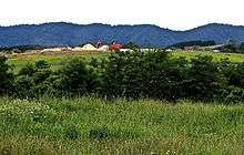
Horotiu is a small township on the west bank of the Waikato River in the Waikato District of New Zealand. It is on the Waikato Plains 13 km (8.1 mi) north of Hamilton and 5 km (3.1 mi) south of Ngāruawāhia. From early in the 20th century it developed around a freezing works and other industries. The North Island Main Trunk railway runs through the town, as did State Highway 1 until opening of part of the Waikato Expressway in 2013. An hourly bus runs between Huntly and Hamilton.[1]
Neighbouring areas | |
|---|---|
Name
The name, Horotiu, seems to have been used interchangeably with Waikato River, or Pukete. Its first use for the current township seems to occur in 1864, shortly after the invasion of the Waikato.[2] Until then, Horotiu was the name of the upper Waikato river, where its current became faster[3] and of Horotiu pā, on its banks, near Cambridge.[4] An 1858 map only shows the name as Horotiu Plains in the area near the pā.[5] The name, Horotiu, for the Waikato River,[6] upstream from Ngāruawāhia,[7] seems to have remained in use until the 1920s,[8] though the 1859 map named it as Waikato.[5]
Horotiu and Pukete parishes existed from at least 1867,[9] but, until the 1900s, Horotiu was often referred to as Pukete, a name now used for the Hamilton suburb 6 km (3.7 mi) upstream. The railway station changed its name on 23 June 1907,[10] when the proposed post office was referred to as Horotiu (Pukete),[11] and the name of the school was changed from Pukete to Horotiu in 1911.[12] The post office closed in 1988.[13]
Demographics
Horotiu area unit had the census figures shown in the table below.[14] Growth to 1,390 is planned by 2040.[15] In the 2013 census, 24.5% of the population were Māori, 6.8% spoke te reo Māori, 10.2% were born overseas, 77.1% were owner-occupiers, 12.4% held a degree, unemployment was 5.3%, 77.4% had Internet access and 560 worked in factories.[16]
| Year | Population | Households | Average income | National average |
|---|---|---|---|---|
| 2001 | 687 | 222 | $20,700 | $18,500 |
| 2006 | 786 | 261 | $27,500 | $24,100 |
| 2013 | 771 | 279 | $33,000 | $27,900 |
Geology
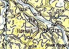
Taupo Pumice Alluvium (Q1a) was deposited on the Hinuera Formation (Q2a) until about 15,000 years ago. Some of the alluvium has been dug for sand and gravel. The Hinuera formation is also sand and gravel, interbedded with silt and some peat.[17] In the last 14,000 years the Waikato River has cut into these formations, forming a low terrace and then cutting deeper.[18]
The low ridge between the Waikato and Waipa rivers is made of Walton Subgroup (eQa – pumiceous fine-grained sand and silt with interbedded peat, pumiceous gravelly sand, diatomaceous mud, and non-welded ignimbrite and tephra), covered in places by Piako Subgroup (1Qa – Late Pleistocene, mainly locally derived, stream and coastal alluvium, and minor fans, with up to 20 m (66 ft) of unconsolidated to very soft, thinly to thickly bedded, yellow-grey to orange-brown, pumiceous mud, silt, sandy mud and gravel, with muddy peat in some valleys).[18]
History
Ngāti Hauā had a pā named Horotiu near Cambridge[19] and they also had land in this area.[20] The 1858 census put the Ngāti Hauā population at 1,399.[21] By then they had seeded this area with European grasses.[2] Their land was confiscated in 1864.[6]
Education
Horotiu Playcentre and Horotiu Primary School provide local education.[22] In 2016 Horotiu had years 1–8, with a roll of 227.[23] The 2012 report on the school said, "The vast majority of students are achieving at or above National Standards" and noted it was in a Decile 3 area.[24] The school dates back to 1879,[25] following a government grant of the land in 1878.[26]
Freezing works and dairy
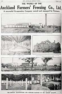
Auckland Farmers Cooperative (later Allied Farmers – AFFCO)[27] bought 80 acres (32 ha) in 1914[27] and a riverside gravel pit in 1915.[28] Horotiu Freezing Works opened on 17 January 1916.[29] Horotiu still has AFFCO’s head office[30] and its largest beef processing plant.[31] The parent company, Talley's, plan to open a Waikato Dairy Co dried milk plant on the same site in 2018.[32] The area has long been associated with dairying, a casein factory having opened in 1919.[33] AFFCO has long been involved with strikes[34] and pollution.[35][36]
Business park
Northgate business park, between Horotiu and Te Rapa, covers 109 ha (270 acres)[22] and opened in 2013.[37] Ports of Auckland have 33ha in Northgate for a freight hub.[38]
Gravel, landfill and power station
By 1904 the area was recognised as a source of gravel[39] and pits were established by 1907,[40] especially on the east bank,[41] and continue to produce aggregates and take in clean fill.[42] Other landfilling ended in 2006, when a 1999 consent[17] for a Hamilton City Council landfill expired. It had been started in October 1985 on a 95 ha (230 acres) sand pit (worked from about 1970 to 2000) and was replaced by Hampton Downs. It was closed earlier than originally planned, due to leachate problems.[43] The 1999 consent required use of a vacuum to extract gas from the bores and leachate.[17] Therefore, from November 2004 until 2012, when the emissions declined, methane from the landfill ran a 900kWe Waukesha VHP5904LTD Enginator gas engine generator set.[44]
Cycleway
The Horotiu-Pukete section of Te Awa River Ride opened in 2013[45] and an extension to Ngāruawāhia opened on 2 Nov 2017.[46]
Bridges
Near Horotiu the Waikato is bridged by 2 roads and Te Awa cycleway.
The next bridge upstream is Pukete sewer bridge and downstream, Ngāruawāhia road bridge.
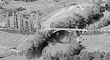
1921 Horotiu Bridge Rd
Construction started about 1920 of a reinforced concrete bridge, with a 25 ft (7.6 m) high arch, a main span of 126 ft (38 m), plus six approach spans of 24 ft (7.3 m), carrying a 16 ft (4.9 m) wide road. It was designed by Toogood and Jones, of Auckland, for £7900, paid by Waikato and Waipa County Councils,[47] though government contributed £1,728.[48][49] The bridge was completed in 1921,[50] though the approaches took longer.[51]
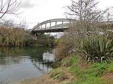
2001 Horotiu Bridge Rd
The Category II listed bridge was deemed unsafe and replaced in 2001.[52]
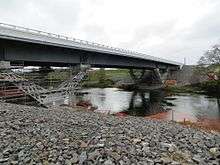
2013 Waikato Expressway bridge
The need for the 2001 bridge was reduced by the 142 m (466 ft) long 2013 Waikato Expressway Te Rehu O Waikato Bridge, built 400 m (1,300 ft) upstream. As part of the $200m road section,[53] it used 800 tonnes of steel, including 56 tonne girders, resting on 4 x 'V'-shaped piers,[54] which allowed the main span to be reduced about 20m to 55 m (180 ft).[55] Concrete pre-cast panels were added to them to carry the concrete deck and barriers.[54]
2017 cycleway

The Te Awa cycle bridge is a 140m long, 2.5m wide, [56] $1.3m cable network arch bridge,[57] opened on Thursday 2 November 2017.[46] The bridge is lit from a 9kWh battery, powered by 2 x 100 watt wind turbines and 2 x 250 watt solar panels on 7-metre high masts at the base of the bridge.[58] Since opening the average weekly use by cyclists rose from 133 to 711 and by walkers from 348 to 391.[59]

See also
References
- ↑ "21". busit.co.nz. Retrieved 10 June 2017.
- 1 2 "THE WAIPA AND HOROTIU DISTRICT. (New Zealander, 1864-03-16)". paperspast.natlib.govt.nz National Library of New Zealand. Retrieved 14 June 2017.
- ↑ "The Railways Magazine: Railway Station Maori Names". nzetc.victoria.ac.nz. 1 October 1935. Retrieved 14 June 2017.
- ↑ "Waikato Expressway Cambridge Section – Archaeological investigations" (PDF). NZTA.
- 1 2 The southern part of the Province of Auckland showing the routes and surveys by Ferdinand von Hochstetter, 1859. "Inmagic DB/Text WebPublisher PRO: 1 records". www.aucklandcity.govt.nz. Retrieved 14 June 2017.
- 1 2 "Proclamation of Native Lands under the New Zealand Settlements Act. (Daily Southern Cross, 1865-06-21)". paperspast.natlib.govt.nz National Library of New Zealand. Retrieved 10 June 2017.
- ↑ "New Zealand Herald, 1873-02-10". paperspast.natlib.govt.nz National Library of New Zealand. Retrieved 11 June 2017.
- ↑ "THE WAIKATO RIVER. (New Zealand Herald, 1928-03-06)". paperspast.natlib.govt.nz National Library of New Zealand. Retrieved 11 June 2017.
- ↑ "The Daily Southern Cross. (1867-08-02)". paperspast.natlib.govt.nz National Library of New Zealand. Retrieved 13 June 2017.
- ↑ Scoble, Juliet (2010). "Names & Opening & Closing Dates of Railway Stations in New Zealand 1863 to 2010" (PDF). Rail Heritage Trust of New Zealand.
- ↑ "The Waikato Argus. TUESDAY, MAY 21, 1907". paperspast.natlib.govt.nz National Library of New Zealand. Retrieved 13 June 2017.
- ↑ "BOARD OF EDUCATION. (Waikato Argus, 1911-06-22)". paperspast.natlib.govt.nz National Library of New Zealand. Retrieved 13 June 2017.
- ↑ "Our History". Pukete School. Retrieved 18 June 2017.
- ↑ "2013 Census map – QuickStats about a place". www.stats.govt.nz. Retrieved 10 June 2017.
- ↑ "Ngaaruawaahia, Hopuhopu, Taupiri, Horotiu, Te Kowhai & Glen Massey Structure Plan" (PDF). Waikato District Council. March 2017.
- ↑ "QuickStats about a place". www.stats.govt.nz. Retrieved 15 June 2017.
- 1 2 3 Nigel Edger, Opus International Consultants. "HOROTIU LANDFILL STAGE 6B: DESIGN, CONSTRUCTION & CONSTRUCTION QUALITY ASSURANCE" (PDF).
- 1 2 EDBROOKE, S. W. "Geology of the Waikato Area 1:250 000 geological map 4". Institute of Geological & Nuclear Sciences.
- ↑ "CAMBRIDGE MUSEUM – ARCHAEOLOGICAL SITES". cambridgemuseum.org.nz. Retrieved 13 June 2017.
- ↑ Taonga, New Zealand Ministry for Culture and Heritage Te Manatu. "Te Waharoa". www.teara.govt.nz. Retrieved 13 June 2017.
- ↑ "New Zealander 16 September 1863". paperspast.natlib.govt.nz National Library of New Zealand. Retrieved 14 June 2017.
- 1 2 "Horotiu". www.waikatodistrict.govt.nz. Retrieved 10 June 2017.
- ↑ "Horotiu School - 28/06/2017". Education Review Office. Retrieved 2018-06-21.
- ↑ "Horotiu School – 06/08/2012". Education Review Office. Retrieved 11 June 2017.
- ↑ "The Horotiu School centennial, 1879–1979; a record of the past 100 years of the Pukete-Horotiu School's development and of the celebration of the centennial". DigitalNZ. 1 January 1979. Retrieved 13 June 2017.
- ↑ "PUKETE, LANDING RESERVE AND SCHOOL SITE. (Waikato Times, 1878-05-18)". paperspast.natlib.govt.nz National Library of New Zealand. Retrieved 13 June 2017.
- 1 2 "3. – Stock and station agencies – Te Ara Encyclopedia of New Zealand". www.teara.govt.nz. Retrieved 12 June 2017.
- ↑ "WAIKATO FREEZING WORKS. (Waikato Times, 1915-02-10)". paperspast.natlib.govt.nz National Library of New Zealand. Retrieved 13 June 2017.
- ↑ "HOROTIU FREEZING WORKS (Waikato Times, 1916-01-18)". paperspast.natlib.govt.nz National Library of New Zealand. Retrieved 11 June 2017.
- ↑ "Head office". www.affco.co.nz. Retrieved 11 June 2017.
- ↑ "PROCESSING PLANTS". www.affco.co.nz. Retrieved 11 June 2017.
- ↑ "Open Country Dairy building new factory in Waikato". Stuff. Retrieved 11 June 2017.
- ↑ "CASEIN FACTORY AT HOROTIU. (King Country Chronicle, 1919-01-28)". paperspast.natlib.govt.nz National Library of New Zealand. Retrieved 11 June 2017.
- ↑ "THE HOROTIU STRIKE (Waikato Times, 1917-04-30)". paperspast.natlib.govt.nz National Library of New Zealand. Retrieved 15 June 2017.
- ↑ "Council grants Horotiu consents". Waikato Regional Council. Retrieved 15 June 2017.
- ↑ "Applications in for a suite of replacement consents to cover the ongoing operation of the meat processing plant at Horotiu". Waikato Regional Council. 7 December 2015.
- ↑ Tunstall, Kashka (23 October 2013). "Northgate business park complex nearly ready". Stuff.co.nz. Retrieved 12 June 2017.
- ↑ "Waikato Towns are in close proximity to Auckland and Hamilton. – Open Waikato". openwaikato.co.nz. Retrieved 10 June 2017.
- ↑ "NEWCASTLE ROAD BOARD (Waikato Times, 1904-08-12)". paperspast.natlib.govt.nz National Library of New Zealand. Retrieved 13 June 2017.
- ↑ "NEWCASTLE ROAD BOARD. (Waikato Times, 1907-06-14)". paperspast.natlib.govt.nz National Library of New Zealand. Retrieved 13 June 2017.
- ↑ "HEWCASTLE ROAD BOARD (Waikato Times, 1916-10-12)". paperspast.natlib.govt.nz National Library of New Zealand. Retrieved 11 June 2017.
- ↑ "Horotiu". www.perryresources.co.nz. Retrieved 11 June 2017.
- ↑ Mohobane, Thabiso (2008). "The characteristics and impacts of landfill leachate from Horotiu" (PDF). University of Waikato.
- ↑ "Portfolio / Entec, powering the energy industry". www.entec.co.nz. Retrieved 10 June 2017.
- ↑ "Our Route & Maps". Te Awa. Retrieved 11 June 2017.
- 1 2 "Over 5,000 New Zealanders take part in the Aotearoa mini Bike Challenge". nzta-cycling.cmail19.com. Retrieved 2017-11-03.
- ↑ "HOROTIU BRIDGE (Waikato Times, 1919-10-27)". paperspast.natlib.govt.nz National Library of New Zealand. Retrieved 11 June 2017.
- ↑ "Parliamentary Papers Appropriations for Public Works Services. CLASS XXVI.—ROADS, ETC. 1920 Session I". paperspast.natlib.govt.nz National Library of New Zealand. Retrieved 11 June 2017.
- ↑ "Parliamentary Papers Appropriations for Public Works Services 1922 Session". paperspast.natlib.govt.nz National Library of New Zealand. Retrieved 11 June 2017.
- ↑ "Parliamentary Papers CONSTRUCTION, MAINTENANCE, AND SUPERVISION OF ROADS AND BRIDGES. 1921 Session I-II". paperspast.natlib.govt.nz National Library of New Zealand. Retrieved 11 June 2017.
- ↑ "HOROTIU BRIDGE (Waikato Times, 1921-09-14)". paperspast.natlib.govt.nz National Library of New Zealand. Retrieved 11 June 2017.
- ↑ "Lost Heritage 2000–2004 Heritage New Zealand". www.heritage.org.nz. Retrieved 11 June 2017.
- ↑ "Second section of Waikato Expressway to open this Saturday at 11.30am". NZ Transport Agency. Retrieved 11 June 2017.
- 1 2 "Cental Today Oct/Nov 2013". www.eastbridge.co.nz. Retrieved 11 June 2017.
- ↑ "'Te Rehu o Waikato' (the Mist of Waikato) – DC Structures Studio". www.dcstructuresstudio.com. Retrieved 11 June 2017.
- ↑ "Iconic cycle bridge to call Waikato home". Waikato District Council. September 2016.
- ↑ "$1.3m bridge to provide missing link for two-wheeled travellers". Stuff. Retrieved 11 June 2017.
- ↑ "WEL Networks goes off-grid | Scoop News". www.scoop.co.nz. Retrieved 2017-11-03.
- ↑ "Iconic bridge attracts cyclists in their droves". Waikato District Council. Retrieved 2018-06-14.
External links
- Horotiu on 1:50,000 map
- Horotiu on Google Street View
- Horotiu school
- Waikato River swimming water quality and LAWA water quality
- National Library aerial photos 1930 (works), 1955 (bridge, town, station, works), 1959 (town, station and works), 1963 (bridge, town, works), 1979 (works)
- Facebook video of placing of cycle bridge