Atiamuri
| Atiamuri | |
|---|---|
| Hydro village | |
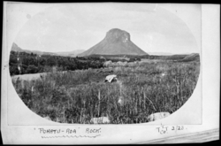 Pōhaturoa Rock, 1923 | |
 Atiamuri | |
| Coordinates: 38°23′37″S 176°01′41″E / 38.3937°S 176.0280°E | |
| District | Rotorua District |
| Country | New Zealand |
Atiamuri is a former Hydro village in the central North Island of New Zealand. It lies alongside State Highway One about 45 km north of Taupo. It is bordered by the Waikato River and surrounded by pine plantations. Upper Atimauri, just north of the Waikato River, is a small community of lifestyle blocks, dairy farms and farm servicing businesses.
Mount Pōhaturoa (520 m) is a distinctive volcanic plug that dominates the Atiamuri landscape.[1] It overlooks Lake Atiamuri which was formed behind the hydroelectric Atiamuri Power Station. This very visible rocky outcrop is significant in both Arawa and Ngati Raukawa history, having been a strategic observation post during intertribal conflicts.[2]
Lake Atiamuri was formed by the Atiamuri hydroelectric power station after it was completed in 1958. The lake extends about 5 km upstream towards Taupo before meeting the Ohakuri Hydro Dam. The area offers some great trout fishing.
Demographics
Parts of the area known as Atiamuri straddle three District Council boundaries; Rotorua[3] (Tatua area unit - 2013 population 288),[4] South Waikato[5] (Wawa area - 711)[4] and Taupo[6] (Marotiri area - 1,557).[4]
The Tatua area includes Atiamuri village,[7] where meshblocks had these statistics - 1275700 - 3 (2013), 9 (2006), 1275800 - 6 (2013), 3 (2006) and 1276000 - 3 (2013), 6 (2006).[4]
The main meshblocks of the village are -
1275900[4]
| Year | Population | Households |
Average income | National average |
|---|---|---|---|---|
| 2001 | 45 | 15 | $12,500 | $18,500 |
| 2006 | 33 | 12 | $15,800 | $24,100 |
| 2013 | 30 | 9 | $22,500 | $27,900 |
and 1276100[4]
| Year | Population | Households |
Average income |
|---|---|---|---|
| 2001 | 36 | 12 | $7,500 |
| 2006 | 18 | 6 | $3,300 |
| 2013 | 21 | 9 | $36,300 |
Atiamuri Power Station
Atiamuri Power Station is a hydroelectric power station on the Waikato River owned by Mercury Energy. It has a total capacity of 84 MW and was first commissioned in 1958.[8]
References
- ↑ Woodcut of Mount Pohaturoa Archived June 12, 2011, at the Wayback Machine..
- ↑ "Atiamuri". South Waikato District Council.
- ↑ "ATIAMURI GEOTHERMAL FIELD" (PDF). Waikato Regional Council. 2011.
- 1 2 3 4 5 6 "2013 Census map – QuickStats about a place". archive.stats.govt.nz. Retrieved 2018-09-14.
- ↑ "Atiamuri - South Waikato District Council". www.southwaikato.govt.nz. Retrieved 2018-09-14.
- ↑ "Mangakino - Taupo District Council". www.taupodc.govt.nz. Retrieved 2018-09-14.
- ↑ "Atiamuri, Waikato - NZ Topo Map". NZ Topo Map. Retrieved 2018-09-14.
- ↑ Atiamuri Archived June 10, 2011, at the Wayback Machine., Mighty River Power, New Zealand.