Villesèquelande
| Villesèquelande | ||
|---|---|---|
| Commune | ||
| ||
 Villesèquelande Location within Occitanie region  Villesèquelande | ||
| Coordinates: 43°14′18″N 2°13′56″E / 43.2383°N 2.2322°ECoordinates: 43°14′18″N 2°13′56″E / 43.2383°N 2.2322°E | ||
| Country | France | |
| Region | Occitanie | |
| Department | Aude | |
| Arrondissement | Carcassonne | |
| Canton | La Malepère à la Montagne Noire | |
| Intercommunality | Cabardès-Canal du Midi | |
| Government | ||
| • Mayor (2008–20114) | Jacques Brunel | |
| Area1 | 5.35 km2 (2.07 sq mi) | |
| Population (2008)2 | 811 | |
| • Density | 150/km2 (390/sq mi) | |
| Time zone | UTC+1 (CET) | |
| • Summer (DST) | UTC+2 (CEST) | |
| INSEE/Postal code | 11437 /11170 | |
| Elevation |
104–160 m (341–525 ft) (avg. 119 m or 390 ft) | |
|
1 French Land Register data, which excludes lakes, ponds, glaciers > 1 km2 (0.386 sq mi or 247 acres) and river estuaries. 2 Population without double counting: residents of multiple communes (e.g., students and military personnel) only counted once. | ||
.svg.png)
Villesèquelande is a commune near Carcassonne in the Aude department in southern France. It is noted for the ancient field elm, the Ormeau Sully, allegedly planted by Maximilien de Béthune, Duke of Sully in the early 17th century in front of the church in the village centre.
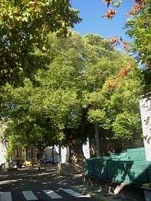
The 'Ormeau Sully'
Population
| Historical population | ||
|---|---|---|
| Year | Pop. | ±% |
| 1793 | 392 | — |
| 1800 | 440 | +12.2% |
| 1806 | 427 | −3.0% |
| 1821 | 464 | +8.7% |
| 1831 | 410 | −11.6% |
| 1836 | 379 | −7.6% |
| 1841 | 384 | +1.3% |
| 1846 | 393 | +2.3% |
| 1851 | 385 | −2.0% |
| 1856 | 378 | −1.8% |
| 1861 | 379 | +0.3% |
| 1866 | 362 | −4.5% |
| 1872 | 315 | −13.0% |
| 1876 | 327 | +3.8% |
| 1881 | 311 | −4.9% |
| 1886 | 321 | +3.2% |
| 1891 | 364 | +13.4% |
| 1896 | 355 | −2.5% |
| 1901 | 395 | +11.3% |
| 1906 | 414 | +4.8% |
| 1911 | 406 | −1.9% |
| 1921 | 384 | −5.4% |
| 1926 | 393 | +2.3% |
| 1931 | 400 | +1.8% |
| 1936 | 390 | −2.5% |
| 1946 | 350 | −10.3% |
| 1954 | 355 | +1.4% |
| 1962 | 348 | −2.0% |
| 1968 | 342 | −1.7% |
| 1975 | 455 | +33.0% |
| 1982 | 521 | +14.5% |
| 1990 | 506 | −2.9% |
| 1999 | 568 | +12.3% |
| 2008 | 811 | +42.8% |
See also
References
| Wikimedia Commons has media related to Villesèquelande. |
This article is issued from
Wikipedia.
The text is licensed under Creative Commons - Attribution - Sharealike.
Additional terms may apply for the media files.