Quirbajou
| Quirbajou | ||
|---|---|---|
| Commune | ||
 | ||
| ||
 Quirbajou Location within Occitanie region  Quirbajou | ||
| Coordinates: 42°49′50″N 2°10′46″E / 42.8306°N 2.1794°ECoordinates: 42°49′50″N 2°10′46″E / 42.8306°N 2.1794°E | ||
| Country | France | |
| Region | Occitanie | |
| Department | Aude | |
| Arrondissement | Limoux | |
| Canton | La Haute-Vallée de l'Aude | |
| Intercommunality | Canton of Axat | |
| Government | ||
| • Mayor (2008–2014) | Hubert Manichon | |
| Area1 | 13.95 km2 (5.39 sq mi) | |
| Population (2008)2 | 36 | |
| • Density | 2.6/km2 (6.7/sq mi) | |
| Time zone | UTC+1 (CET) | |
| • Summer (DST) | UTC+2 (CEST) | |
| INSEE/Postal code | 11306 /11500 | |
| Elevation |
360–1,280 m (1,180–4,200 ft) (avg. 820 m or 2,690 ft) | |
|
1 French Land Register data, which excludes lakes, ponds, glaciers > 1 km2 (0.386 sq mi or 247 acres) and river estuaries. 2 Population without double counting: residents of multiple communes (e.g., students and military personnel) only counted once. | ||
.svg.png)
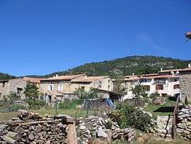
Quirbajou is a commune in the Aude department in southern France.
Population
| Historical population | ||
|---|---|---|
| Year | Pop. | ±% |
| 1962 | 22 | — |
| 1968 | 25 | +13.6% |
| 1975 | 18 | −28.0% |
| 1982 | 20 | +11.1% |
| 1990 | 29 | +45.0% |
| 1999 | 38 | +31.0% |
| 2008 | 36 | −5.3% |
History
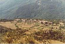
View of the French village of Quirbajou in the summer of 1985
See also
References
| Wikimedia Commons has media related to Quirbajou. |
This article is issued from
Wikipedia.
The text is licensed under Creative Commons - Attribution - Sharealike.
Additional terms may apply for the media files.