Montredon-des-Corbières
| Montredon-des-Corbières | |
|---|---|
| Commune | |
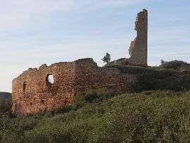 Ruins of the chateau of Saint Pierre des Clars | |
 Montredon-des-Corbières Location within Occitanie region  Montredon-des-Corbières | |
| Coordinates: 43°11′32″N 2°55′36″E / 43.1922°N 2.9267°ECoordinates: 43°11′32″N 2°55′36″E / 43.1922°N 2.9267°E | |
| Country | France |
| Region | Occitanie |
| Department | Aude |
| Arrondissement | Narbonne |
| Canton | Narbonne-1 |
| Intercommunality | Narbonnaise |
| Government | |
| • Mayor (2014–2020) | Éric Mellet |
| Area1 | 17.15 km2 (6.62 sq mi) |
| Population (2008)2 | 1,104 |
| • Density | 64/km2 (170/sq mi) |
| Time zone | UTC+1 (CET) |
| • Summer (DST) | UTC+2 (CEST) |
| INSEE/Postal code | 11255 /11100 |
| Elevation |
28–176 m (92–577 ft) (avg. 35 m or 115 ft) |
|
1 French Land Register data, which excludes lakes, ponds, glaciers > 1 km2 (0.386 sq mi or 247 acres) and river estuaries. 2 Population without double counting: residents of multiple communes (e.g., students and military personnel) only counted once. | |
Montredon-des-Corbières is a commune in the Aude department in southern France.
Population
| Historical population | ||
|---|---|---|
| Year | Pop. | ±% |
| 1962 | 640 | — |
| 1968 | 645 | +0.8% |
| 1975 | 717 | +11.2% |
| 1982 | 729 | +1.7% |
| 1990 | 850 | +16.6% |
| 1999 | 904 | +6.4% |
| 2008 | 1,104 | +22.1% |
See also
References
| Wikimedia Commons has media related to Montredon-des-Corbières. |
This article is issued from
Wikipedia.
The text is licensed under Creative Commons - Attribution - Sharealike.
Additional terms may apply for the media files.