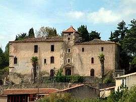
Montazels
| Montazels | ||
|---|---|---|
| Commune | ||
 | ||
| ||
 Montazels Location within Occitanie region  Montazels | ||
| Coordinates: 42°56′46″N 2°14′48″E / 42.9461°N 2.2467°ECoordinates: 42°56′46″N 2°14′48″E / 42.9461°N 2.2467°E | ||
| Country | France | |
| Region | Occitanie | |
| Department | Aude | |
| Arrondissement | Limoux | |
| Canton | La Haute-Vallée de l'Aude | |
| Intercommunality | Pays de Couiza | |
| Government | ||
| • Mayor (2008–2014) | André Fromilhague | |
| Area1 | 4.39 km2 (1.69 sq mi) | |
| Population (2008)2 | 492 | |
| • Density | 110/km2 (290/sq mi) | |
| Time zone | UTC+1 (CET) | |
| • Summer (DST) | UTC+2 (CEST) | |
| INSEE/Postal code | 11240 /11190 | |
| Elevation |
211–527 m (692–1,729 ft) (avg. 235 m or 771 ft) | |
|
1 French Land Register data, which excludes lakes, ponds, glaciers > 1 km2 (0.386 sq mi or 247 acres) and river estuaries. 2 Population without double counting: residents of multiple communes (e.g., students and military personnel) only counted once. | ||
.svg.png)
Montazels is a commune in the Aude department in the Occitanie region of France.
Population
| Historical population | ||
|---|---|---|
| Year | Pop. | ±% |
| 1962 | 382 | — |
| 1968 | 399 | +4.5% |
| 1975 | 459 | +15.0% |
| 1982 | 462 | +0.7% |
| 1990 | 506 | +9.5% |
| 1999 | 469 | −7.3% |
| 2008 | 492 | +4.9% |
Personalities
Bérenger Saunière, controversial Roman Catholic priest of Rennes-le-Château, was born in Montazels on 11 April 1852.
See also
References
| Wikimedia Commons has media related to Montazels. |
This article is issued from
Wikipedia.
The text is licensed under Creative Commons - Attribution - Sharealike.
Additional terms may apply for the media files.