Gruissan
| Gruissan | ||
|---|---|---|
| Commune | ||
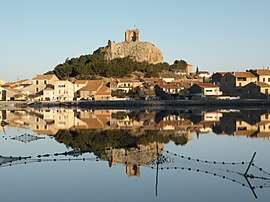 Historical city centre with the ruin of the Barberousse tower | ||
| ||
 Gruissan Location within Occitanie region  Gruissan | ||
| Coordinates: 43°06′28″N 3°05′20″E / 43.1078°N 3.0889°ECoordinates: 43°06′28″N 3°05′20″E / 43.1078°N 3.0889°E | ||
| Country | France | |
| Region | Occitanie | |
| Department | Aude | |
| Arrondissement | Narbonne | |
| Canton | Narbonne-2 | |
| Intercommunality | Narbonnaise | |
| Government | ||
| • Mayor (2008–2014) | Didier Codorniou | |
| Area1 | 43.65 km2 (16.85 sq mi) | |
| Population (2008)2 | 4,410 | |
| • Density | 100/km2 (260/sq mi) | |
| Time zone | UTC+1 (CET) | |
| • Summer (DST) | UTC+2 (CEST) | |
| INSEE/Postal code | 11170 /11430 | |
| Elevation |
0–200 m (0–656 ft) (avg. 2 m or 6.6 ft) | |
|
1 French Land Register data, which excludes lakes, ponds, glaciers > 1 km2 (0.386 sq mi or 247 acres) and river estuaries. 2 Population without double counting: residents of multiple communes (e.g., students and military personnel) only counted once. | ||
.svg.png)
Gruissan is a commune in the Aude department in southern France. The historian Émile Raunié (1854–1911) was born in Gruissan.
Population
| Historical population | ||
|---|---|---|
| Year | Pop. | ±% |
| 1962 | 1,200 | — |
| 1968 | 1,258 | +4.8% |
| 1975 | 1,269 | +0.9% |
| 1982 | 1,594 | +25.6% |
| 1990 | 2,170 | +36.1% |
| 1999 | 3,091 | +42.4% |
| 2004 | 3,531 | +14.2% |
| 2008 | 4,410 | +24.9% |
The Town
Situated on the Mediterranean coast of Southern France, Gruissan is situated in the Parc naturel régional de la Narbonnaise en Méditerranée. Traditionally a fishing village, the circular town is built around the former castle; a 10th century château of which only the Tour Barberousse (Redbeard Tower) remains.[1]
See also
References
- ↑ "It's Grand in Gruissan | P-O Life". anglophone-direct. 2018-10-14. Retrieved 2018-10-14.
| Wikimedia Commons has media related to Gruissan. |
This article is issued from
Wikipedia.
The text is licensed under Creative Commons - Attribution - Sharealike.
Additional terms may apply for the media files.