Coursan
| Coursan | ||
|---|---|---|
| Commune | ||
 | ||
| ||
 Coursan Location within Occitanie region  Coursan | ||
| Coordinates: 43°13′57″N 3°03′32″E / 43.2325°N 3.0589°ECoordinates: 43°13′57″N 3°03′32″E / 43.2325°N 3.0589°E | ||
| Country | France | |
| Region | Occitanie | |
| Department | Aude | |
| Arrondissement | Narbonne | |
| Canton | Les Basses Plaines de l'Aude | |
| Intercommunality | Narbonnaise | |
| Government | ||
| • Mayor (2008–2014) | Gilbert Pla (PCF) | |
| Area1 | 24.61 km2 (9.50 sq mi) | |
| Population (2007)2 | 6,124 | |
| • Density | 250/km2 (640/sq mi) | |
| Time zone | UTC+1 (CET) | |
| • Summer (DST) | UTC+2 (CEST) | |
| INSEE/Postal code | 11106 /11110 | |
| Elevation | 0–14 m (0–46 ft) | |
|
1 French Land Register data, which excludes lakes, ponds, glaciers > 1 km2 (0.386 sq mi or 247 acres) and river estuaries. 2 Population without double counting: residents of multiple communes (e.g., students and military personnel) only counted once. | ||
.svg.png)
Coursan is a commune in the Aude department in southern France.
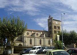
It is 7 km from Narbonne on the Aude. There is a bridge built in the fifteenth century, over which passes the RN9 road. The town has a church from the same period which is in the course of being restored.
Population
| Historical population | ||
|---|---|---|
| Year | Pop. | ±% |
| 1793 | 1,440 | — |
| 1800 | 1,436 | −0.3% |
| 1806 | 1,414 | −1.5% |
| 1821 | 1,630 | +15.3% |
| 1831 | 1,761 | +8.0% |
| 1836 | 1,850 | +5.1% |
| 1841 | 2,022 | +9.3% |
| 1846 | 2,040 | +0.9% |
| 1851 | 2,172 | +6.5% |
| 1856 | 2,231 | +2.7% |
| 1861 | 2,154 | −3.5% |
| 1866 | 2,447 | +13.6% |
| 1872 | 2,538 | +3.7% |
| 1876 | 2,709 | +6.7% |
| 1881 | 3,458 | +27.6% |
| 1886 | 3,786 | +9.5% |
| 1891 | 3,847 | +1.6% |
| 1896 | 3,767 | −2.1% |
| 1901 | 3,829 | +1.6% |
| 1906 | 3,802 | −0.7% |
| 1911 | 3,793 | −0.2% |
| 1921 | 4,121 | +8.6% |
| 1926 | 4,273 | +3.7% |
| 1931 | 4,438 | +3.9% |
| 1936 | 3,589 | −19.1% |
| 1946 | 3,271 | −8.9% |
| 1954 | 3,228 | −1.3% |
| 1962 | 3,212 | −0.5% |
| 1968 | 3,366 | +4.8% |
| 1975 | 3,334 | −1.0% |
| 1982 | 4,021 | +20.6% |
| 1990 | 5,137 | +27.8% |
| 1999 | 5,241 | +2.0% |
| 2008 | 6,124 | +16.8% |
See also
References
External links
| Wikimedia Commons has media related to Coursan. |
- (in French) Official site
This article is issued from
Wikipedia.
The text is licensed under Creative Commons - Attribution - Sharealike.
Additional terms may apply for the media files.