Fontcouverte, Aude
| Fontcouverte | ||
|---|---|---|
| Commune | ||
 | ||
| ||
 Fontcouverte Location within Occitanie region  Fontcouverte | ||
| Coordinates: 43°10′08″N 2°41′22″E / 43.1689°N 2.6894°ECoordinates: 43°10′08″N 2°41′22″E / 43.1689°N 2.6894°E | ||
| Country | France | |
| Region | Occitanie | |
| Department | Aude | |
| Arrondissement | Narbonne | |
| Canton | Les Corbières | |
| Intercommunality | Région Lézignanaise | |
| Government | ||
| • Mayor (2008–2014) | Alain Calhavel | |
| Area1 | 9.97 km2 (3.85 sq mi) | |
| Population (2008)2 | 563 | |
| • Density | 56/km2 (150/sq mi) | |
| Time zone | UTC+1 (CET) | |
| • Summer (DST) | UTC+2 (CEST) | |
| INSEE/Postal code | 11148 /11700 | |
| Elevation |
62–189 m (203–620 ft) (avg. 65 m or 213 ft) | |
|
1 French Land Register data, which excludes lakes, ponds, glaciers > 1 km2 (0.386 sq mi or 247 acres) and river estuaries. 2 Population without double counting: residents of multiple communes (e.g., students and military personnel) only counted once. | ||
.svg.png)
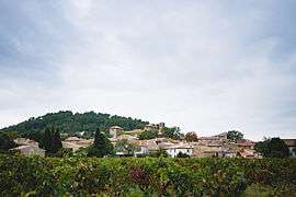
Fontcouverte is a commune in the Aude department in southern France.
Population
| Historical population | ||
|---|---|---|
| Year | Pop. | ±% |
| 1962 | 388 | — |
| 1968 | 397 | +2.3% |
| 1975 | 336 | −15.4% |
| 1982 | 328 | −2.4% |
| 1990 | 333 | +1.5% |
| 1999 | 424 | +27.3% |
| 2008 | 563 | +32.8% |
Sights
- Monument Saint Régis
- Fountain on the Place de la Révolution, built in the late 19th century
- A column 4.40 m high with a statue of a woman symbolizing agriculture
- Montagne d'Alaric
See also
References
| Wikimedia Commons has media related to Fontcouverte, Aude. |
This article is issued from
Wikipedia.
The text is licensed under Creative Commons - Attribution - Sharealike.
Additional terms may apply for the media files.