Uza, Landes
| Uza | |
|---|---|
| Commune | |
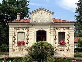 Town hall | |
 Uza Location within Nouvelle-Aquitaine region  Uza | |
| Coordinates: 44°02′02″N 1°11′57″W / 44.0339°N 1.1992°WCoordinates: 44°02′02″N 1°11′57″W / 44.0339°N 1.1992°W | |
| Country | France |
| Region | Nouvelle-Aquitaine |
| Department | Landes |
| Arrondissement | Dax |
| Canton | Côte d'Argent |
| Intercommunality | Côte Landes Nature |
| Government | |
| • Mayor (2014–2020) | Jean-Jacques Leblond |
| Area1 | 12.88 km2 (4.97 sq mi) |
| Population (2013)2 | 159 |
| • Density | 12/km2 (32/sq mi) |
| Time zone | UTC+1 (CET) |
| • Summer (DST) | UTC+2 (CEST) |
| INSEE/Postal code | 40322 /40170 |
| Elevation |
12–44 m (39–144 ft) (avg. 10 m or 33 ft) |
|
1 French Land Register data, which excludes lakes, ponds, glaciers > 1 km2 (0.386 sq mi or 247 acres) and river estuaries. 2 Population without double counting: residents of multiple communes (e.g., students and military personnel) only counted once. | |
Uza is a commune in the Landes department in Nouvelle-Aquitaine in southwestern France.
Population
| Historical population | ||
|---|---|---|
| Year | Pop. | ±% |
| 1872 | 613 | — |
| 1881 | 586 | −4.4% |
| 1891 | 558 | −4.8% |
| 1901 | 587 | +5.2% |
| 1911 | 521 | −11.2% |
| 1921 | 451 | −13.4% |
| 1931 | 398 | −11.8% |
| 1946 | 332 | −16.6% |
| 1954 | 347 | +4.5% |
| 1962 | 354 | +2.0% |
| 1968 | 313 | −11.6% |
| 1975 | 307 | −1.9% |
| 1982 | 234 | −23.8% |
| 1990 | 184 | −21.4% |
| 2008 | 157 | −14.7% |
| 2013 | 159 | +1.3% |
See also
References
| Wikimedia Commons has media related to Uza. |
This article is issued from
Wikipedia.
The text is licensed under Creative Commons - Attribution - Sharealike.
Additional terms may apply for the media files.