Argelouse
| Argelouse | |
|---|---|
| Commune | |
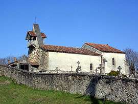 The church of Argelouse | |
 Argelouse Location within Nouvelle-Aquitaine region  Argelouse | |
| Coordinates: 44°22′01″N 0°38′42″W / 44.3669°N 0.645°WCoordinates: 44°22′01″N 0°38′42″W / 44.3669°N 0.645°W | |
| Country | France |
| Region | Nouvelle-Aquitaine |
| Department | Landes |
| Arrondissement | Mont-de-Marsan |
| Canton | Haute Lande Armagnac |
| Intercommunality | CC Cœur Haute Lande |
| Government | |
| • Mayor (2014-2020) | Anne-Lise Lalanne |
| Area1 | 22.79 km2 (8.80 sq mi) |
| Population (2015)2 | 85 |
| • Density | 3.7/km2 (9.7/sq mi) |
| Time zone | UTC+1 (CET) |
| • Summer (DST) | UTC+2 (CEST) |
| INSEE/Postal code | 40008 /40430 |
| Elevation |
39–73 m (128–240 ft) (avg. 61 m or 200 ft) |
|
1 French Land Register data, which excludes lakes, ponds, glaciers > 1 km2 (0.386 sq mi or 247 acres) and river estuaries. 2 Population without double counting: residents of multiple communes (e.g., students and military personnel) only counted once. | |
Argelouse (Occitan: Argelosa) is a commune of the Landes department in Nouvelle-Aquitaine in southwestern France.
Population
| Historical population | ||
|---|---|---|
| Year | Pop. | ±% |
| 1962 | 21 | — |
| 1968 | 37 | +76.2% |
| 1975 | 37 | +0.0% |
| 1982 | 55 | +48.6% |
| 1990 | 54 | −1.8% |
| 1999 | 55 | +1.9% |
| 2006 | 81 | +47.3% |
| 2009 | 94 | +16.0% |
| 2015 | 85 | −9.6% |
See also
References
| Wikimedia Commons has media related to Argelouse. |
This article is issued from
Wikipedia.
The text is licensed under Creative Commons - Attribution - Sharealike.
Additional terms may apply for the media files.