Mano, Landes
| Mano | |
|---|---|
| Commune | |
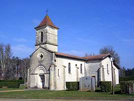 Church at Mano | |
 Mano Location within Nouvelle-Aquitaine region  Mano | |
| Coordinates: 44°25′05″N 0°40′15″W / 44.4181°N 0.6708°WCoordinates: 44°25′05″N 0°40′15″W / 44.4181°N 0.6708°W | |
| Country | France |
| Region | Nouvelle-Aquitaine |
| Department | Landes |
| Arrondissement | Mont-de-Marsan |
| Canton | Grands Lacs |
| Intercommunality | Communauté de communes du canton de Pissos |
| Government | |
| • Mayor (2008–2014) | Jean-Marc Hédoin |
| Area1 | 32.27 km2 (12.46 sq mi) |
| Population (2006)2 | 95 |
| • Density | 2.9/km2 (7.6/sq mi) |
| Time zone | UTC+1 (CET) |
| • Summer (DST) | UTC+2 (CEST) |
| INSEE/Postal code | 40171 /40410 |
| Elevation |
38–74 m (125–243 ft) (avg. 63 m or 207 ft) |
|
1 French Land Register data, which excludes lakes, ponds, glaciers > 1 km2 (0.386 sq mi or 247 acres) and river estuaries. 2 Population without double counting: residents of multiple communes (e.g., students and military personnel) only counted once. | |
Mano is a commune in the Landes department in Nouvelle-Aquitaine in south-western France.
See also
| Wikimedia Commons has media related to Mano (Landes). |
This article is issued from
Wikipedia.
The text is licensed under Creative Commons - Attribution - Sharealike.
Additional terms may apply for the media files.