Maylis
| Maylis | |
|---|---|
| Commune | |
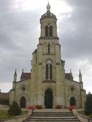 The church of Our Lady, in Maylis | |
 Maylis Location within Nouvelle-Aquitaine region  Maylis | |
| Coordinates: 43°41′52″N 0°40′46″W / 43.6978°N 0.6794°WCoordinates: 43°41′52″N 0°40′46″W / 43.6978°N 0.6794°W | |
| Country | France |
| Region | Nouvelle-Aquitaine |
| Department | Landes |
| Arrondissement | Dax |
| Canton | Coteau de Chalosse |
| Intercommunality | Communauté de communes du canton de Mugron |
| Government | |
| • Mayor (2008–2014) | Sylvie Marsan |
| Area1 | 12.21 km2 (4.71 sq mi) |
| Population (2007)2 | 334 |
| • Density | 27/km2 (71/sq mi) |
| Time zone | UTC+1 (CET) |
| • Summer (DST) | UTC+2 (CEST) |
| INSEE/Postal code | 40177 /40250 |
| Elevation |
43–122 m (141–400 ft) (avg. 83 m or 272 ft) |
|
1 French Land Register data, which excludes lakes, ponds, glaciers > 1 km2 (0.386 sq mi or 247 acres) and river estuaries. 2 Population without double counting: residents of multiple communes (e.g., students and military personnel) only counted once. | |
Maylis is a commune in the Landes department in Nouvelle-Aquitaine in south-western France.
See also
| Wikimedia Commons has media related to Maylis (Landes). |
This article is issued from
Wikipedia.
The text is licensed under Creative Commons - Attribution - Sharealike.
Additional terms may apply for the media files.