Capbreton
| Capbreton | ||
|---|---|---|
| Commune | ||
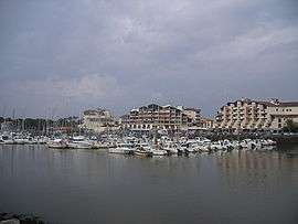 Marina | ||
| ||
 Capbreton Location within Nouvelle-Aquitaine region  Capbreton | ||
| Coordinates: 43°38′35″N 1°25′52″W / 43.6431°N 1.4311°WCoordinates: 43°38′35″N 1°25′52″W / 43.6431°N 1.4311°W | ||
| Country | France | |
| Region | Nouvelle-Aquitaine | |
| Department | Landes | |
| Arrondissement | Dax | |
| Canton | Pays Tyrossais | |
| Intercommunality | Maremne-Adour-Côte-Sud | |
| Government | ||
| • Mayor (2014–2020) | Patrick Laclédère | |
| Area1 | 21.75 km2 (8.40 sq mi) | |
| Population (2013)2 | 8,396 | |
| • Density | 390/km2 (1,000/sq mi) | |
| Time zone | UTC+1 (CET) | |
| • Summer (DST) | UTC+2 (CEST) | |
| INSEE/Postal code | 40065 /40130 | |
| Elevation |
0–51 m (0–167 ft) (avg. 10 m or 33 ft) | |
|
1 French Land Register data, which excludes lakes, ponds, glaciers > 1 km2 (0.386 sq mi or 247 acres) and river estuaries. 2 Population without double counting: residents of multiple communes (e.g., students and military personnel) only counted once. | ||

Capbreton (Cap Berton in Occitan) is a commune in the Landes department in Nouvelle-Aquitaine in southwestern France. Located at the mouth of the Boudigau and Bourret rivers, the town is situated about 40 km north of Biarritz.
The town is a popular holiday destination for sailors, surfers, and beach-goers.
Population
| Historical population | ||
|---|---|---|
| Year | Pop. | ±% |
| 1793 | 537 | — |
| 1806 | 586 | +9.1% |
| 1821 | 706 | +20.5% |
| 1831 | 915 | +29.6% |
| 1841 | 968 | +5.8% |
| 1851 | 1,060 | +9.5% |
| 1861 | 1,180 | +11.3% |
| 1872 | 1,247 | +5.7% |
| 1881 | 1,151 | −7.7% |
| 1891 | 1,284 | +11.6% |
| 1901 | 1,313 | +2.3% |
| 1911 | 1,518 | +15.6% |
| 1921 | 1,565 | +3.1% |
| 1931 | 2,954 | +88.8% |
| 1946 | 3,126 | +5.8% |
| 1954 | 3,534 | +13.1% |
| 1962 | 3,688 | +4.4% |
| 1968 | 3,937 | +6.8% |
| 1975 | 4,263 | +8.3% |
| 1982 | 4,456 | +4.5% |
| 1990 | 5,089 | +14.2% |
| 1999 | 6,659 | +30.9% |
| 2008 | 7,763 | +16.6% |
| 2013 | 8,396 | +8.2% |
See also
References
| Wikimedia Commons has media related to Capbreton. |
This article is issued from
Wikipedia.
The text is licensed under Creative Commons - Attribution - Sharealike.
Additional terms may apply for the media files.