Lauret, Landes
| Lauret | |
|---|---|
| Commune | |
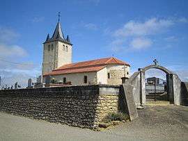 The church in Lauret | |
 Lauret Location within Nouvelle-Aquitaine region  Lauret | |
| Coordinates: 43°33′50″N 0°20′34″W / 43.5639°N 0.3428°WCoordinates: 43°33′50″N 0°20′34″W / 43.5639°N 0.3428°W | |
| Country | France |
| Region | Nouvelle-Aquitaine |
| Department | Landes |
| Arrondissement | Mont-de-Marsan |
| Canton | Chalosse Tursan |
| Intercommunality | Communauté de communes du Tursan |
| Government | |
| • Mayor (2008–2014) | Stéphane Cabanne |
| Area1 | 7.34 km2 (2.83 sq mi) |
| Population (2006)2 | 78 |
| • Density | 11/km2 (28/sq mi) |
| Time zone | UTC+1 (CET) |
| • Summer (DST) | UTC+2 (CEST) |
| INSEE/Postal code | 40148 /40320 |
| Elevation |
117–237 m (384–778 ft) (avg. 228 m or 748 ft) |
|
1 French Land Register data, which excludes lakes, ponds, glaciers > 1 km2 (0.386 sq mi or 247 acres) and river estuaries. 2 Population without double counting: residents of multiple communes (e.g., students and military personnel) only counted once. | |
Lauret is a commune in the Landes department in Nouvelle-Aquitaine in south-western France.
See also
| Wikimedia Commons has media related to Lauret (Landes). |
This article is issued from
Wikipedia.
The text is licensed under Creative Commons - Attribution - Sharealike.
Additional terms may apply for the media files.