U.S. Route 64 in Arkansas
| ||||
|---|---|---|---|---|
_map.svg.png) | ||||
| Route information | ||||
| Maintained by AHTD | ||||
| Length | 246.35 mi[1] (396.46 km) | |||
| Existed | 1926–present | |||
| Major junctions | ||||
| West end |
| |||
|
| ||||
| East end |
| |||
| Highway system | ||||
| ||||
.svg.png)
U.S. Route 64 is a U.S. highway running from Teec Nos Pos, Arizona east to Nags Head, North Carolina. In the U.S. state of Arkansas, the route runs 246.35 miles (396.46 km) from the Oklahoma border in Fort Smith east to the Tennessee border in Memphis.[1] The route passes through several cities and towns, including Fort Smith, Clarksville, Russellville, Conway, Searcy, and West Memphis. US 64 runs parallel to Interstate 40 until Conway, when I-40 takes a more southerly route.
Route description
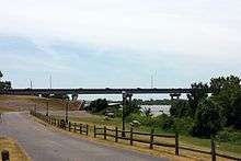
US 64 crosses Arkansas' western border over the Arkansas River, heading southeast into downtown Ft. Smith. Upon entry to Arkansas, the highway passes the Fort Smith National Historic Site, Ft. Smith Confederate Monument, Commercial Hotel and the West Garrison Avenue Historic District, all on the National Register of Historic Places. The highway turns northwest near the New Theatre, following the Arkansas and Missouri Railroad and concurring with US 71 Business onto 10th and 11th Streets.[2] Westbound traffic runs on 10th St and eastbound traffic on 11th St past the Fort Smith Masonic Temple. Traffic converges onto Midland Boulevard.[3] US 64 crosses the Arkansas River again near the American Doughboy Monument as it enters Van Buren on Broadway. US 64 passes the Van Buren Post Office before turning east onto Main Street, then northeast again becoming the Alma Highway. US 64 passes a former alignment, now designated as Oak St. After Oak St, US 64 crosses I-540 and continues east to Alma.[4] US 64 closely follows Interstate 40 until Conway, while also closely following the Arkansas River, the Union Pacific Railroad, and the southern edge of the Ozark National Forest.
US 64 continues through mountainous Franklin County, intersecting the Pig Trail Scenic Byway in Ozark.[5] The route passes the Franklin County Courthouse, and the Ozark Courthouse Square Historic District in Ozark before exiting town continuing east. Route 64 passes a historically significant connector road in Wiederkehr Village before entering Altus and entering Johnson County. US 64 runs through Coal Hill and Hartman before curving northeast and crossing over I-40. The route continues to Clarksville, home of the University of the Ozarks.[6] The route passes the Johnson County Courthouse, historic American Legion Hut, Clarksville Municipal Airport, and Lake Dardanelle before again crossing over I-40 and entering Pope County.[7] US 64 then parallels Interstate 40, through, Russellville, and Morrilton. It briefly converges with U.S. Route 65B through Conway heading south before diverging from US 65 Business and Interstate 40 by turning east onto Oak Street. US 64 then travels east to Beebe where it originally entered town via Center Street and joined with US 67 and US 167. This former route has since been resigned Arkansas Highway 367, as all three US highways have been relocated to a concurrent divided highway northwest of Beebe.
US 64 runs along this divided highway past Searcy where its original route took it north along Main Street, then east along Race Avenue. This former route is now signed US 67 Business. Later, US 64, 67, and 167 were rerouted southeast of Searcy along Eastline Road, which is now signed Arkansas Highway 367. Currently, all three highways continue to run northeast along a divided highway running parallel to Eastline Road.
US 64 diverges from US 67 & 167 on the northeast side of Bald Knob where its former route took it downtown along Highway Avenue, which is now signed Arkansas Highway 367. US 64 turns east, while the divided US 67 diverges northeast, and US 167 diverges north.
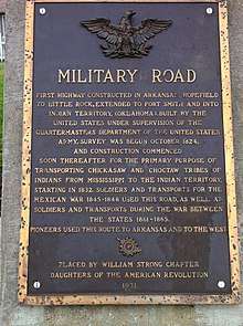
US 64 continues east through Augusta and McCrory bypassing Wynne through Earle and Crawfordsville until joining with Interstate 55 at Marion. Its former route continued east along Military Road, turning south onto the Great River Road, and converging with US 63, which has since also been rerouted along Interstate 55. The former route is signed Arkansas Highway 77.
US 64 continues south to West Memphis, where its former route entered the town from the north via Missouri Street, turning east (diverging from US 63 while converging with US 70 & 79) onto Broadway. Its current route turns east north of West Memphis as Interstates 55 and 40 briefly converge, before entering Tennessee (and downtown Memphis) along the Interstate 55 bridge.
Each August, a large yard sale similar to the Highway 127 Corridor Sale takes place along 160 mi (260 km) of US 64 in Arkansas.[8]
Major intersections
| County | Location | mi[1] | km | Destinations | Notes | ||
|---|---|---|---|---|---|---|---|
| Sebastian | Fort Smith | 0.0 | 0.0 | Oklahoma state line (Garrison Avenue Bridge over the Arkansas River) | |||
| 0.3 | 0.48 | ||||||
| 0.7 | 1.1 | West end of US 71B overlap | |||||
| 4.8 | 7.7 | ||||||
| Arkansas River | 5.5 | 8.9 | Bridge | ||||
| Crawford | Van Buren | 5.9 | 9.5 | West end of AR 59 overlap | |||
| 6.3 | 10.1 | East end of AR 59 overlap | |||||
| 6.9 | 11.1 | ||||||
| 8.2 | 13.2 | I-540 exit 2 | |||||
| 8.8 | 14.2 | ||||||
| | 10.3 | 16.6 | |||||
| Alma | 14.0 | 22.5 | East end of US 71B overlap | ||||
| 15.3 | 24.6 | ||||||
| Mulberry | |||||||
| 24.8 | 39.9 | ||||||
| Franklin | | 28.5 | 45.9 | ||||
| Ozark | 36.5 | 58.7 | |||||
| 37.8 | 60.8 | West end of AR 23 overlap | |||||
| 38.5 | 62.0 | East end of AR 23 overlap | |||||
| 38.8 | 62.4 | ||||||
| Altus | 43.7 | 70.3 | |||||
| 44.0 | 70.8 | ||||||
| Johnson | Coal Hill | 51.2 | 82.4 | ||||
| Clarksville | 60.7 | 97.7 | |||||
| 61.6 | 99.1 | I-40 exit 55 | |||||
| 62.4 | 100.4 | ||||||
| 65.0 | 104.6 | West end of AR 103 overlap | |||||
| 65.4 | 105.3 | East end of AR 103 overlap | |||||
| 66.4 | 106.9 | ||||||
| Lamar | 67.9 | 109.3 | West end of AR 123 overlap | ||||
| 69.8 | 112.3 | East end of AR 123 overlap | |||||
| 70.1 | 112.8 | ||||||
| 72.0 | 115.9 | I-40 exit 64 | |||||
| Knoxville | 74.5 | 119.9 | |||||
| Piney | |||||||
| Pope | London | 82.3 | 132.4 | ||||
| 84.8 | 136.5 | ||||||
| I-40 exit 78 | |||||||
| Russellville | 87.6 | 141.0 | West end of AR 326 overlap | ||||
| 87.8 | 141.3 | East end of AR 326 overlap | |||||
| 90.6 | 145.8 | ||||||
| 91.4 | 147.1 | ||||||
| 92.2 | 148.4 | ||||||
| 92.4 | 148.7 | West end of AR 331 overlap | |||||
| 92.9 | 149.5 | East end of AR 331 overlap | |||||
| 93.1 | 149.8 | ||||||
| Pottsville | 96.1 | 154.7 | |||||
| 96.9 | 155.9 | ||||||
| Atkins | 102.6 | 165.1 | |||||
| 102.7 | 165.3 | ||||||
| Conway | | ||||||
| | 109.2 | 175.7 | |||||
| Morrilton | 115.9 | 186.5 | |||||
| 116.2 | 187.0 | ||||||
| 117.4 | 188.9 | interchange | |||||
| Plumerville | 121.9 | 196.2 | |||||
| Menifee | 126.9 | 204.2 | |||||
| Faulkner | Conway | 130.5 | 210.0 | ||||
| 134.2 | 216.0 | ||||||
| 134.9 | 217.1 | ||||||
| 135.6 | 218.2 | West end of US 65B overlap | |||||
| 136.3 | 219.4 | Siebenmorgen Road (AR 266) / Markham Street | roundabout | ||||
| 136.8 | 220.2 | East end of US 65B overlap | |||||
| 137.6 | 221.4 | I-40 exit 127 | |||||
| Hamlet | 144.4 | 232.4 | |||||
| Funston | 150.6 | 242.4 | |||||
| | |||||||
| White | | 157.1 | 252.8 | ||||
| Beebe | 168.7 | 271.5 | interchange; West end of US 67 / US 167 overlap; US 64 west follows exit 28 | ||||
| see US 67 | |||||||
| Bald Knob | 196.1 | 315.6 | interchange; East end of US 67 / US 167 overlap; US 64 east follows exit 55 | ||||
| 196.4 | 316.1 | ||||||
| Woodruff | Augusta | 208.5 | 335.5 | ||||
| 208.8 | 336.0 | ||||||
| 209.6 | 337.3 | ||||||
| | 210.0 | 338.0 | |||||
| Patterson | 216.4 | 348.3 | West end of AR 17 overlap | ||||
| McCrory | 218.4 | 351.5 | East end of AR 17 overlap | ||||
| | 221.7 | 356.8 | |||||
| | 224.3 | 361.0 | West end of AR 269 overlap | ||||
| Morton | 224.8 | 361.8 | East end of AR 269 overlap | ||||
| Cross | Fair Oaks | West end of US 49 overlap | |||||
| East end of US 49 overlap | |||||||
| Central | 234.0 | 376.6 | |||||
| | 234.9 | 378.0 | |||||
| | 239.6 | 385.6 | |||||
| Wynne | 242.0 | 389.5 | West end of AR 1 overlap | ||||
| 242.6 | 390.4 | East end of AR 1 overlap | |||||
| | 246.1 | 396.1 | |||||
| Levesque | 246.7 | 397.0 | |||||
| 246.8 | 397.2 | ||||||
| | 254.9 | 410.2 | West end of AR 75 overlap | ||||
| Parkin | 256.1 | 412.2 | East end of AR 75 overlap | ||||
| 256.2 | 412.3 | ||||||
| 257.3 | 414.1 | ||||||
| Crittenden | | 259.7 | 417.9 | ||||
| Earle | 261.1 | 420.2 | |||||
| 261.4 | 420.7 | ||||||
| 262.4 | 422.3 | ||||||
| | 270.4 | 435.2 | |||||
| | 271.4 | 436.8 | |||||
| | 273.0 | 439.4 | |||||
| Marion | 277.6 | 446.8 | |||||
| 278.3 | 447.9 | West end of I-55 / US 61 / US 63 overlap; US 64 west follows exit 10 | |||||
| see I-55 | |||||||
| | 289.4 | 465.7 | Tennessee state line (Memphis & Arkansas Bridge over the Mississippi River) | ||||
| 1.000 mi = 1.609 km; 1.000 km = 0.621 mi | |||||||
See also
- Special routes of U.S. Route 64, six special routes of US 64 exist in Arkansas
References
Route map:
- 1 2 3 "[Arkansas] State Highways 2009 (Database)." April 2010. AHTD: Planning and Research Division. Database. Archived 2011-07-07 at the Wayback Machine. Retrieved April 11, 2011.
- ↑ Map of Fort Smith, Sebastian County, Arkansas (Map) (January 2006 ed.). Arkansas State Highway and Transportation Department. Retrieved March 24, 2011.
- ↑ General Highway Map - Sebastian County, Arkansas (PDF) (Map) (5/10/10 ed.). Arkansas State Highway and Transportation Department. Retrieved March 24, 2011.
- ↑ General Highway Map - Crawford County, Arkansas (PDF) (Map) (5/10/10 ed.). Arkansas State Highway and Transportation Department. Retrieved March 24, 2011.
- ↑ General Highway Map - Franklin County, Arkansas (PDF) (Map) (1/3/11 ed.). Arkansas State Highway and Transportation Department. Retrieved March 24, 2011.
- ↑ Map of Clarksville, Johnson County, Arkansas (PDF) (Map) (May 2006 ed.). Arkansas State Highway and Transportation Department. Retrieved March 24, 2011.
- ↑ General Highway Map - Johnson County, Arkansas (PDF) (Map) (2/8/11 ed.). Arkansas State Highway and Transportation Department. Retrieved March 24, 2011.
- ↑ http://www.bargainsgaloreon64.com/
| Previous state: Oklahoma |
Arkansas | Next state: Tennessee |