Levesque, Arkansas
| Levesque, Arkansas | |
|---|---|
| Unincorporated community | |
 Levesque, Arkansas  Levesque, Arkansas | |
| Coordinates: 35°14′57″N 90°42′38″W / 35.24917°N 90.71056°WCoordinates: 35°14′57″N 90°42′38″W / 35.24917°N 90.71056°W | |
| Country | United States |
| State | Arkansas |
| County | Cross |
| Elevation | 230 ft (70 m) |
| Time zone | UTC-6 (Central (CST)) |
| • Summer (DST) | UTC-5 (CDT) |
| Area code(s) | 870 |
| GNIS feature ID | 77480[1] |
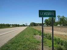
Levesque is an unincorporated community in Cross County, Arkansas, United States. Levesque is located at the junction of U.S. Route 64 and Arkansas Highway 163, 4.6 miles (7.4 km) east-northeast of Wynne.[2]
References
- ↑ "Levesque". Geographic Names Information System. United States Geological Survey.
- ↑ Cross County, Arkansas General Highway Map (PDF) (Map). Arkansas State Highway and Transportation Department. 2007. Retrieved December 3, 2012.
Municipalities and communities of Cross County, Arkansas, United States | ||
|---|---|---|
| Cities | 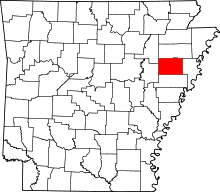 | |
| Unincorporated communities | ||
This article is issued from
Wikipedia.
The text is licensed under Creative Commons - Attribution - Sharealike.
Additional terms may apply for the media files.