Arkansas Highway 326
| ||||
|---|---|---|---|---|
 | ||||
| Route information | ||||
| Maintained by ArDOT | ||||
| Existed | June 1965 – present | |||
| Section 1 | ||||
| Length | 9.96 mi[1] (16.03 km) | |||
| From end |
| |||
| To end |
| |||
| Section 2 | ||||
| Length | 1.50 mi[1] (2.41 km) | |||
| West end |
| |||
| East end |
| |||
| Section 3 | ||||
| Length | 6.52 mi[1] (10.49 km) | |||
| West end |
| |||
| East end |
| |||
| Location | ||||
| Counties | Pope | |||
| Highway system | ||||
| ||||

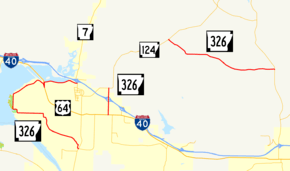
Highway 326 (AR 326, Ark. 326, and Hwy. 326) is a designation for three state highways in Pope County. One route of 9.96 miles (16.03 km) in Russellville begins at Highway 7 and Highway 7 Truck and runs northeast to Highway 7. A second route of 1.50 miles (2.41 km) in Russellville begins at US Highway 64 (US 64) and runs north to Highway 124. A third route of 6.52 miles (10.49 km) begins at Highway 124 and runs east to Highway 105. All routes are maintained by the Arkansas State Highway and Transportation Department (AHTD).
Route description
Russellville
The route begins at AR 7 at the intersection with AR 7 Truck in south Russellville. Highway 326 runs west past the Confederate Mothers Memorial Park and the Mountain View School to Lake Dardanelle State Park, and continues north along the shore of Lake Dardanelle. The route concurs briefly with U.S. Route 64 near Washburn Park, after which it runs east to meet Highway 7, where it terminates.[2]
Weir Road
Highway 326 begins at US 64 in eastern Russellville and runs due north as Weir Road. The highway passes through a commercial area before an interchange with Interstate 40 approximately midway along the route. Continuing north, the highway intersects Highway 124, where it terminates.
Gum Log to Highway 105
Highway 326 begins at Highway 124 near the community of Gum Log and runs east to Highway 105. This segment of Highway 326 does not cross or concur with any other state highways.
History
Highway 326 was first created by the Arkansas State Highway Commission on June 23, 1965 between US 64 and Skyline Drive in Russellville.[3] A second route was created on October 27, 1965 between US 64 and Highway 124, as it exists today.[4] In 1973, the Arkansas General Assembly passed Act 9 of 1973. The act directed county judges and legislators to designate up to 12 miles (19 km) of county roads as state highways in each county.[5] As a result of this legislation, a third segment of Highway 326 was designated on May 23, 1973 between Gum Log and Highway 105.[6]
The segment in Russellville was extended on May 23, 1979 between US 64 and Highway 7. The ASHC adopted a United States Army Corps of Engineers levee road constructed along the Illinois Bayou arm of Lake Dardanelle into the state highway system.[7] Highway 326 was extended south from Skyline Drive to its present southern terminus on August 13, 1980.[8]
Major intersections
Mile markers reset at concurrencies. The entire route is in Pope County.
| Location | mi[1] | km | Destinations | Notes | |||
|---|---|---|---|---|---|---|---|
| Russellville | 0.00 | 0.00 | Western terminus | ||||
| 8.06– 0.00 | 12.97– 0.00 | ||||||
| 1.90 | 3.06 | Eastern terminus | |||||
| Gap in route | |||||||
| 0.00 | 0.00 | Western terminus | |||||
| 0.78 | 1.26 | ||||||
| 1.50 | 2.41 | Eastern terminus | |||||
| Gap in route | |||||||
| Gum Log | 0.00 | 0.00 | Western terminus | ||||
| | 6.52 | 10.49 | Eastern terminus | ||||
1.000 mi = 1.609 km; 1.000 km = 0.621 mi
| |||||||
See also
References
- 1 2 3 4 System Information and Research Division (2014). "Arkansas Road Log Database" (MDB). Arkansas State Highway and Transportation Department. Retrieved March 27, 2016.
- ↑ Arkansas State Highway and Transportation Department (March 23, 2016). General Highway Map, Pope County, Arkansas (PDF) (Map). 1:62500. Arkansas State Highway and Transportation Department. Retrieved January 1, 2017.
- ↑ "Minutes" & 1953–69, p. 673.
- ↑ "Minutes" & 1953–69, p. 739.
- ↑ Planning and Research Division, Policy Analysis Section (2010). Development of Highway and Transportation Legislation in Arkansas (PDF). A Review of the Acts Relative to Administering and Financing Highways and Transportation in Arkansas. Little Rock: Arkansas State Highway and Transportation Department. p. 13. Retrieved December 4, 2016.
- ↑ "Minutes" & 1970–79, p. 1170.
- ↑ "Minutes" & 1970–79, p. 95.
- ↑ "Minutes of the Meeting" (PDF). Arkansas State Highway Commission. 1980–89. p. 85. Retrieved January 2, 2017.
- "Minutes of the Meeting" (PDF). Arkansas State Highway Commission. 1953–69. Retrieved January 2, 2017.
- "Minutes of the Meeting" (PDF). Arkansas State Highway Commission. 1970–79. Retrieved January 2, 2017.
External links
Route map:
![]()