Johnson County Line-Ozark-Crawford County Line Road, Altus Segment
|
Johnson County Line-Ozark-Crawford County Line Road, Altus Segment | |
 | |
  | |
| Nearest city | Altus, Arkansas |
|---|---|
| Coordinates | 35°28′31″N 93°46′49″W / 35.47528°N 93.78028°WCoordinates: 35°28′31″N 93°46′49″W / 35.47528°N 93.78028°W |
| Area | less than one acre |
| Built | 1918 |
| MPS | Arkansas Highway History and Architecture MPS |
| NRHP reference # | 10000033[1] |
| Added to NRHP | February 24, 2010 |
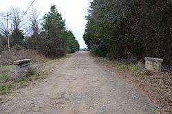
The Johnson County Line-Ozark-Crawford County Line Road, Altus Segment is a historic roadbed in Altus, Arkansas. It consists of a 425-foot (130 m) section of stone-paved roadbed, located on the north side of Arkansas Highway 64 between Robin Way and County Road 515. The roadbed is about 10 feet (3.0 m) wide, with gravel shoulders, and has a small concrete bridge spanning a ditch. Built sometime between c. 1918 and 1931, it is the only known example of stone pavement in rural Arkansas.[2]
The road section was listed on the National Register of Historic Places in 2010.[1]
See also
References
- 1 2 National Park Service (2010-07-09). "National Register Information System". National Register of Historic Places. National Park Service.
- ↑ "NRHP nomination for Johnson County Line-Ozark-Crawford County Line Road, Altus Segment" (PDF). Arkansas Preservation. Retrieved 2015-09-21.
| Topics | |
|---|---|
| Lists by states |
|
| Lists by insular areas | |
| Lists by associated states | |
| Other areas | |
| |
This article is issued from
Wikipedia.
The text is licensed under Creative Commons - Attribution - Sharealike.
Additional terms may apply for the media files.