Van Buren, Arkansas
| Van Buren, Arkansas | |
|---|---|
| City | |
| City of Van Buren | |
 Clockwise, from top: US 64/US 71B bridge over the Arkansas River, Van Buren Train Depot, Crawford County Bank Building, Main Street in the Van Buren Historic District, Crawford County Courthouse | |
 Location of Van Buren in Crawford County, Arkansas. | |
 Van Buren Location within the contiguous United States of America | |
| Coordinates: 35°26′40″N 94°20′48″W / 35.44444°N 94.34667°WCoordinates: 35°26′40″N 94°20′48″W / 35.44444°N 94.34667°W | |
| Country |
|
| State |
|
| County | Crawford |
| Township(s) | Dora, Van Buren |
| Incorporated | January 4, 1845 |
| Named for | Martin Van Buren |
| Government[1] | |
| • Type | Mayor–Council |
| • Mayor | Bob Freeman (I) |
| • Council | |
| Area[2] | |
| • City | 16.28 sq mi (42.15 km2) |
| • Land | 15.36 sq mi (39.79 km2) |
| • Water | 0.91 sq mi (2.37 km2) |
| Elevation | 401 ft (122 m) |
| Population (2010) | |
| • City | 22,791 |
| • Estimate (2017)[3] | 23,509 |
| • Density | 1,530.33/sq mi (590.88/km2) |
| • Metro | 273,170 (Fort Smith metropolitan area) |
| Time zone | UTC-6 (CST) |
| • Summer (DST) | UTC-5 (CDT) |
| ZIP code(s) | 72956 |
| Area code(s) | 479 |
| FIPS code | 05-71480 |
| GNIS feature ID | 0078647 |
| Major airport | FSM |
| Website |
vanburencity |
Van Buren /væn
History

Early history
The area was settled by David Boyd and Thomas Martin in 1818. After Arkansas became a territory in 1819 Daniel and Thomas Phillips constructed a lumber yard in the community to serve as a fuel depot for traffic along the Arkansas River. In 1831 a post office was constructed for the community, at the time known as Phillips Landing. This post office was named after the newly appointed Secretary of State, Martin Van Buren.[6]
John Drennen, along with his partner David Thompson, purchased the area for US$11,000. They moved their business of supplying firewood for steamboats to this new location on higher ground. The courthouse was constructed on a lot of land donated by Drennen on the condition that Van Buren become the county seat. The Drennen Reserve is one of the town's existing historical sites from the 1830s.[7]
Van Buren was incorporated on January 4, 1845.[8]
American Civil War
On December 28, 1862, Union and Confederate forces clashed in and around Van Buren resulting in a defeat for Major-General T. C. Hindman, driving him south across the river with minimal casualties. Federal forces captured 100 prisoners, as stated in an official report by U.S. Major-General Samuel R. Curtis.[9]
1996 tornado
On April 21, 1996, at 11:12 p.m., a category F3 tornado hit the Fort Smith/Van Buren area causing extensive damage. The tornado, which spawned in Oklahoma and crossed into west Fort Smith near the confluence of the Arkansas and Poteau rivers, killed two, injured 89 and caused $300 million in damage. The fatalities were small children from Fort Smith. At its worst, the tornado was one half mile across. After leaving the downtown area of Fort Smith, it traveled northeast through industrial and residential sections of north Fort Smith, then crossed the Arkansas River again into the Mount Vista area on the west side of Van Buren and damaged a highly residential area where no fatalities occurred, although this area was very populated at the time. The total distance it traveled on the ground was 7 miles (11 km). In total, there were around 1,800 homes damaged, the majority of which were in Van Buren.[10]
Physical geography
Van Buren is located in the southwest corner of Crawford County at 35°26′40″N 94°20′48″W / 35.44444°N 94.34667°W (35.444339, -94.346737).[11] The Arkansas–Oklahoma state line is 2 miles (3 km) to the west. The Arkansas River forms the southern boundary of the city, separating it from Fort Smith of Sebastian County. Lee Creek flows through the western side of the city into the Arkansas River. According to the United States Census Bureau, Van Buren has a total area of 16.5 square miles (42.7 km2), of which 15.4 square miles (40.0 km2) is land and 1.0 square mile (2.7 km2), or 6.34%, is water.[5]
Climate
Van Buren lies within a humid subtropical climate area. The city also lies on the eastern edge of the region known as Tornado Alley. Average temperatures range from 36°F in January, to as high an average of 81 °F in July[12] with temperatures reaching the high 90s and low 100s in August. The average annual temperature is approximately 60 °F. Average precipitation is about 41 total inches, with only six inches being snow.
July and August are the hottest months of the year, with an average high of 93 °F (34 °C) and an average low of 71.5 °F (21.9 °C). Temperatures above 100 °F (37.8 °C) are not uncommon, occurring on average eleven times a year. December and January are the coldest months with an average high of 50.5 °F (10.3 °C) and an average low of 30 °F (−1 °C). Highs below 32 °F (0.0 °C) occur on average five times a year, with 0.2 nights per year dropping below 0 °F (−17.8 °C). The city's highest temperature was 113 °F (45.0 °C), recorded in 1936. The lowest temperature recorded was −15 °F (−26.1 °C), in 1899.
| Climate data for Van Buren, Arkansas | |||||||||||||
|---|---|---|---|---|---|---|---|---|---|---|---|---|---|
| Month | Jan | Feb | Mar | Apr | May | Jun | Jul | Aug | Sep | Oct | Nov | Dec | Year |
| Record high °F (°C) | 81 (27) |
87 (31) |
94 (34) |
96 (36) |
99 (37) |
106 (41) |
111 (44) |
113 (45) |
109 (43) |
96 (36) |
86 (30) |
82 (28) |
113 (45) |
| Average high °F (°C) | 50 (10) |
56 (13) |
65 (18) |
74 (23) |
81 (27) |
88 (31) |
93 (34) |
93 (34) |
85 (29) |
75 (24) |
63 (17) |
51 (11) |
72.7 (22.6) |
| Average low °F (°C) | 29 (−2) |
33 (1) |
41 (5) |
50 (10) |
59 (15) |
68 (20) |
72 (22) |
71 (22) |
62 (17) |
51 (11) |
40 (4) |
31 (−1) |
50.4 (10.2) |
| Record low °F (°C) | −11 (−24) |
−15 (−26) |
7 (−14) |
22 (−6) |
34 (1) |
47 (8) |
50 (10) |
45 (7) |
33 (1) |
22 (−6) |
8 (−13) |
−5 (−21) |
−15 (−26) |
| Average precipitation inches (mm) | 2.81 (71.4) |
2.86 (72.6) |
3.85 (97.8) |
4.30 (109.2) |
5.47 (138.9) |
4.28 (108.7) |
3.30 (83.8) |
2.59 (65.8) |
4.05 (102.9) |
4.32 (109.7) |
4.44 (112.8) |
3.29 (83.6) |
45.4 (1,153.2) |
| Average snowfall inches (cm) | 1.8 (4.6) |
1.3 (3.3) |
0.7 (1.8) |
0 (0) |
0 (0) |
0 (0) |
0 (0) |
0 (0) |
0 (0) |
0 (0) |
0 (0) |
0.7 (1.8) |
4.6 (11.7) |
| Average precipitation days (≥ 0.01 in) | 7.5 | 7.8 | 9.7 | 9.1 | 10.7 | 9.3 | 6.5 | 6.3 | 7.7 | 8.4 | 7.5 | 7.7 | 98.3 |
| Average snowy days (≥ 0.1 in) | 1.0 | 0.8 | 0.4 | 0 | 0 | 0 | 0 | 0 | 0 | 0 | 0.1 | 0.6 | 2.9 |
| Source #1: NOAA [13] | |||||||||||||
| Source #2: The Weather Channel[14] | |||||||||||||

Demographics
| Historical population | |||
|---|---|---|---|
| Census | Pop. | %± | |
| 1850 | 549 | — | |
| 1860 | 979 | 78.3% | |
| 1870 | 985 | 0.6% | |
| 1880 | 1,029 | 4.5% | |
| 1890 | 2,291 | 122.6% | |
| 1900 | 2,573 | 12.3% | |
| 1910 | 3,878 | 50.7% | |
| 1920 | 5,224 | 34.7% | |
| 1930 | 5,182 | −0.8% | |
| 1940 | 5,422 | 4.6% | |
| 1950 | 6,413 | 18.3% | |
| 1960 | 6,787 | 5.8% | |
| 1970 | 8,373 | 23.4% | |
| 1980 | 12,020 | 43.6% | |
| 1990 | 14,979 | 24.6% | |
| 2000 | 18,986 | 26.8% | |
| 2010 | 22,791 | 20.0% | |
| Est. 2017 | 23,509 | [3] | 3.2% |
| U.S. Decennial Census[15] | |||
As of the census[16] of 2000, there were 18,986 people, 6,947 households, and 5,182 families residing in the city. The population density was 1,260.7 people per square mile (486.8/km²). There were 7,427 housing units at an average density of 493.2 per square mile (190.4/km²). The racial makeup of the city was 87.37% White, 1.64% Black or African American, 1.96% Native American, 2.82% Asian, 3.17% from other races, and 3.03% from two or more races. 6.04% of the population were Hispanic or Latino of any race.
There are 6,947 households, of which 40.4% have children under the age of 18 living with them, 56.2% were married couples living together, 14.7% had a female householder with no husband present, and 25.4% are classified as non-families by the United States Census Bureau. Of 6,947 households, 362 are unmarried partner households: 304 heterosexual, 12 same-sex male, and 46 same-sex female households. 21.7% of all households were made up of individuals and 8.2% had someone living alone who was 65 years of age or older. The average household size was 2.67 and the average family size was 3.12.
In the city, the population was spread out with 29.6% under the age of 18, 9.0% from 18 to 24, 30.7% from 25 to 44, 20.1% from 45 to 64, and 10.6% who were 65 years of age or older. The median age was 33 years. For every 100 females, there were 92.0 males. For every 100 females age 18 and over, there were 86.8 males.
The median income for a household in the city was $33,608, and the median income for a family was $37,198. Males had a median income of $28,798 versus $21,201 for females. The per capita income for the city was $14,948. About 13.5% of families and 16.7% of the population were below the poverty line, including 24.4% of those under age 18 and 13.0% of those age 65 or over.
Economy and infrastructure
Van Buren is home to many large corporations within the state and employs a great deal of the city's population within its Port and Industrial Park district. Manufacturing, food processing, and medicine are sustaining industries in Van Buren. Major employers include poultry processors Tyson Foods and Simmons, the Van Buren School District, USA Truck, and Sparks Medical Center - Van Buren.
Culture
Arts and architecture

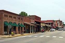
Van Buren is home of the King Opera House, a Victorian-style performance hall from the late 19th century, part of the old downtown historic area. At the south end of the historical downtown is the Crawford County courthouse, the oldest functioning courthouse west of the Mississippi River. To the north is the Old Frisco Station which was originally a station on the St. Louis-San Francisco Railway, pictured at the top of this page.
Media
As part of the primary Fort Smith metropolitan area, many Fort Smith based television stations including KHBS and KFSM, whose radio mast is built in Van Buren, provide local news and weather. The city's major newspaper is the Van Buren Press Argus-Courier, however many people also read Fort Smith's Southwest Times Record, as well as the Northwest Edition of the Arkansas Democrat-Gazette.
Transportation
Van Buren's location at the junction of Interstate 40, Interstate 540, and the Arkansas/Oklahoma border yields surprisingly large tourism and hospitality industries. The city is also located at the junction of several state and U.S. highways including Arkansas Highway 59, US 64, and US 71. A private airport, Twin Cities Airport (code 39AR),[17] was operational to the southeast of the city, but has been closed for many years. Modern railroads in the city include the Arkansas and Missouri Railroad and the Union Pacific Railroad.
Education
The Van Buren School District is the largest school district in Crawford County, consisting of six elementary schools (grades K-5), two middle schools (grades 6-8), one ninth grade academy (grade 9) and one high school (grades 10-12). The Van Buren High School is in the 6A/7A-Central Division of Arkansas high school sports.
Sites of interest

- Historic Main Street, used for scenes in the film The Blue and the Gray as well as scenes in the film Frank & Jesse
- King Opera House, performance hall and historic landmark
- The Old Frisco Station-Victorian style railroad station; used for a scene in the film Biloxi Blues. It was part of the now defunct St. Louis-San Francisco Railway also known as the Frisco.
Notable people
- Justin Boyd, Republican member of the Arkansas House of Representatives from Fort Smith; former Van Buren resident
- Juanita Broaddrick, nursing home owner
- Bob Burns, comedian and actor
- Gary Deffenbaugh, Republican member of the Arkansas House of Representatives from Van Buren; retired educator
- John Deweese, U.S. representative from North Carolina
- Charlene Fite, Republican member of the Arkansas House of Representatives from Van Buren; educator in Fort Smith
- Matt Jones, NFL player
- Natalie White, Survivor Samoa winner
See also
References
- ↑ "Van Buren". Arkansas Municipal League. 2016. Retrieved October 22, 2016.
- ↑ "2017 U.S. Gazetteer Files". United States Census Bureau. Retrieved Aug 22, 2018.
- 1 2 "Population and Housing Unit Estimates". Retrieved March 24, 2018.
- ↑ "Find a County". National Association of Counties. Retrieved 2011-06-07.
- 1 2 "Geographic Identifiers: 2010 Demographic Profile Data (G001): Van Buren city, Arkansas". U.S. Census Bureau, American Factfinder. Retrieved June 19, 2014.
- ↑ History of Benton, Washington, Carroll, Madison, Crawford, Franklin, and Sebastian Counties, Arkansas. Higginson Book Company. 1889. p. 526.
- ↑ "Brief History of Van Buren, AR". Retrieved 2007-08-08.
- ↑ Encyclopedia of Arkansas History & Culture
- ↑ "The Battle of Van Buren, Arkansas - Encounter at Dripping Springs". Retrieved 2007-08-08.
- ↑ Weather.gov Archived 2008-05-16 at the Wayback Machine.
- ↑ "US Gazetteer files: 2010, 2000, and 1990". United States Census Bureau. 2011-02-12. Retrieved 2011-04-23.
- ↑ "Fort Smith USA, Weather History and Climate Data". Retrieved 2008-11-22.
- ↑ "NowData - NOAA Online Weather Data". National Oceanic and Atmospheric Administration. Retrieved July 20, 2013.
- ↑ "Monthly Averages for Van Buren, AR (72956)" (Table). The Weather Channel. Retrieved July 20, 2013.
- ↑ "Census of Population and Housing". Census.gov. Retrieved June 4, 2015.
- ↑ "American FactFinder". United States Census Bureau. Retrieved 2008-01-31.
- ↑ "FAA Coded Departure Routes" (CSV). Retrieved 2007-08-22.
Further reading
- Banasik, Michael E., ed. (1999). "Chapter 2: Into Battle—Prairie Grove and Van Buren [Diary of Events: October 27–December 28, 1862]". Unwritten Chapters of the Civil War West of the River. Volume III: Serving With Honor: The Diary of Captain Eathan Allen Pinnell, Eighth Missouri Infantry (Confederate). Iowa City, Iowa: Camp Pope Bookshop. pp. 23–42. ISBN 0-9628936-9-2. LCCN 99-70729. OCLC 42815700. OL 56184M.
External links
| Wikimedia Commons has media related to Van Buren, Arkansas. |
| Wikivoyage has a travel guide for Van Buren (Arkansas). |
- Government
- General information
Municipalities and communities of Crawford County, Arkansas, United States | ||
|---|---|---|
| Cities | 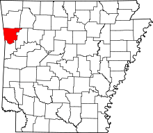 | |
| Towns | ||
| Unincorporated communities | ||
| Ghost towns | ||