McCrory, Arkansas
| McCrory, Arkansas | |
|---|---|
| City | |
 | |
| Motto(s): The Heart of Woodruff County | |
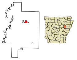 Location of McCrory in Woodruff County, Arkansas. | |
| Coordinates: 35°15′28″N 91°11′48″W / 35.25778°N 91.19667°WCoordinates: 35°15′28″N 91°11′48″W / 35.25778°N 91.19667°W | |
| Country | United States |
| State | Arkansas |
| County | Woodruff |
| Government | |
| • Mayor | Doyle W. Fowler |
| Area[1] | |
| • Total | 2.36 sq mi (6.11 km2) |
| • Land | 2.36 sq mi (6.11 km2) |
| • Water | 0.00 sq mi (0.00 km2) |
| Elevation | 210 ft (64 m) |
| Population (2010) | |
| • Total | 1,729 |
| • Estimate (2017)[2] | 1,555 |
| • Density | 659.74/sq mi (254.70/km2) |
| Time zone | UTC-6 (Central (CST)) |
| • Summer (DST) | UTC-5 (CDT) |
| ZIP code | 72101 |
| Area code(s) | 870 |
| FIPS code | 05-42500 |
| GNIS feature ID | 0058141 |
McCrory is a city in Woodruff County, Arkansas, United States. The population was 1,850 at the 2000 census.
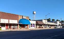
McCrory's Commercial District is listed on the National Register of Historic Places.
Geography
McCrory is located at 35°15′28″N 91°11′48″W / 35.25778°N 91.19667°W (35.257914, -91.196738).[3]
According to the United States Census Bureau, the city has a total area of 2.4 square miles (6.2 km2), all land.
Demographics
| Historical population | |||
|---|---|---|---|
| Census | Pop. | %± | |
| 1890 | 299 | — | |
| 1900 | 225 | −24.7% | |
| 1910 | 637 | 183.1% | |
| 1920 | 687 | 7.8% | |
| 1930 | 924 | 34.5% | |
| 1940 | 1,010 | 9.3% | |
| 1950 | 1,115 | 10.4% | |
| 1960 | 1,053 | −5.6% | |
| 1970 | 1,378 | 30.9% | |
| 1980 | 1,942 | 40.9% | |
| 1990 | 1,971 | 1.5% | |
| 2000 | 1,850 | −6.1% | |
| 2010 | 1,729 | −6.5% | |
| Est. 2017 | 1,555 | [2] | −10.1% |
| U.S. Decennial Census[4] | |||
As of the census[5] of 2000, there were 1,850 people, 752 households, and 482 families residing in the city. The population density was 777.7 people per square mile (300.1/km²). There were 855 housing units at an average density of 359.4/sq mi (138.7/km²). The racial makeup of the city was 79.46% White, 18.92% Black or African American, 0.11% Native American, 0.11% Asian, 0.43% Pacific Islander, 0.11% from other races, and 0.86% from two or more races. 0.92% of the population were Hispanic or Latino of any race.
There were 752 households out of which 31.3% had children under the age of 18 living with them, 44.8% were married couples living together, 16.4% had a female householder with no husband present, and 35.9% were non-families. 32.8% of all households were made up of individuals and 17.7% had someone living alone who was 65 years of age or older. The average household size was 2.31 and the average family size was 2.92.
In the city, the population was spread out with 24.0% under the age of 18, 9.8% from 18 to 24, 22.5% from 25 to 44, 22.3% from 45 to 64, and 21.4% who were 65 years of age or older. The median age was 40 years. For every 100 females, there were 74.5 males. For every 100 females age 18 and over, there were 70.8 males.
The median income for a household in the city was $24,375, and the median income for a family was $32,179. Males had a median income of $26,534 versus $18,050 for females. The per capita income for the city was $15,351. About 16.6% of families and 20.8% of the population were below the poverty line, including 28.3% of those under age 18 and 18.7% of those age 65 or over.
Education
McCrory provides public education from the McCrory School District including the McCrory High School.
References
- ↑ "2017 U.S. Gazetteer Files". United States Census Bureau. Retrieved Aug 22, 2018.
- 1 2 "Population and Housing Unit Estimates". Retrieved March 24, 2018.
- ↑ "US Gazetteer files: 2010, 2000, and 1990". United States Census Bureau. 2011-02-12. Retrieved 2011-04-23.
- ↑ "Census of Population and Housing". Census.gov. Archived from the original on May 12, 2015. Retrieved June 4, 2015.
- ↑ "American FactFinder". United States Census Bureau. Archived from the original on September 11, 2013. Retrieved 2008-01-31.
External links
Municipalities and communities of Woodruff County, Arkansas, United States | ||
|---|---|---|
| Cities | 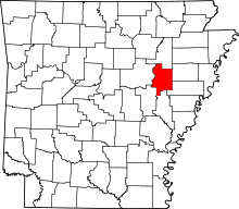 | |
| Town | ||
| Unincorporated communities |
| |
| Ghost towns |
| |
| Footnotes | ‡This populated place also has portions in an adjacent county or counties | |