Conway County, Arkansas
| Conway County, Arkansas | |
|---|---|
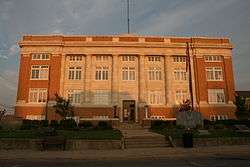 Conway County Courthouse in Morrilton | |
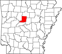 Location in the U.S. state of Arkansas | |
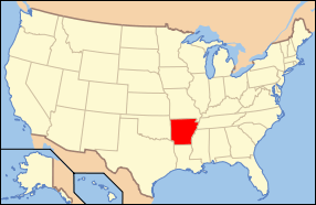 Arkansas's location in the U.S. | |
| Founded | October 20, 1825 |
| Named for | Henry Wharton Conway |
| Seat | Morrilton |
| Largest city | Morrilton |
| Area | |
| • Total | 567 sq mi (1,469 km2) |
| • Land | 552 sq mi (1,430 km2) |
| • Water | 14 sq mi (36 km2), 2.5% |
| Population (est.) | |
| • (2016) | 20,937 |
| • Density | 39/sq mi (15/km2) |
| Congressional district | 2nd |
| Time zone | Central: UTC−6/−5 |
Conway County is a county located in the U.S. state of Arkansas. As of the 2010 census, the population was 21,273.[1] The county seat is Morrilton.[2] The county was formed on October 20, 1825, from a portion of Pulaski County and named for Henry Wharton Conway who was the territorial delegate to the U.S. Congress.
In 2010, the center of population of Arkansas was located in Conway County, near the city of Plumerville.[3]
History
Conway County was formed on October 20, 1825 from a portion of Pulaski County and named for Henry Wharton Conway, who was the territorial delegate to the U.S. Congress. From 1831 until 1883, Lewisburg was the county seat.
Geography
According to the U.S. Census Bureau, the county has a total area of 567 square miles (1,470 km2), of which 552 square miles (1,430 km2) is land and 14 square miles (36 km2) (2.5%) is water.[4] It is the fifth-smallest county in Arkansas by area.
Local Counties
Pope Co. W. Boone Co. N Pulaski Co. SE Pike Co. SW Dallas Co. S. Major HWYs I-40 E U.S. 64 AR HWY 9 AR HWY 92
National protected area
- Ozark National Forest (part)
Demographics
| Historical population | |||
|---|---|---|---|
| Census | Pop. | %± | |
| 1830 | 982 | — | |
| 1840 | 2,892 | 194.5% | |
| 1850 | 3,583 | 23.9% | |
| 1860 | 6,697 | 86.9% | |
| 1870 | 8,112 | 21.1% | |
| 1880 | 12,755 | 57.2% | |
| 1890 | 19,459 | 52.6% | |
| 1900 | 19,772 | 1.6% | |
| 1910 | 22,729 | 15.0% | |
| 1920 | 22,578 | −0.7% | |
| 1930 | 21,949 | −2.8% | |
| 1940 | 21,536 | −1.9% | |
| 1950 | 18,137 | −15.8% | |
| 1960 | 15,430 | −14.9% | |
| 1970 | 16,805 | 8.9% | |
| 1980 | 19,505 | 16.1% | |
| 1990 | 19,151 | −1.8% | |
| 2000 | 20,336 | 6.2% | |
| 2010 | 21,273 | 4.6% | |
| Est. 2016 | 20,937 | [5] | −1.6% |
| U.S. Decennial Census[6] 1790–1960[7] 1900–1990[8] 1990–2000[9] 2010–2016[1] | |||
As of the 2000 United States Census,[11] there were 20,336 people, 7,967 households, and 5,736 families residing in the county. The population density was 37 people per square mile (14/km²). There were 9,028 housing units at an average density of 16 per square mile (6/km²). The racial makeup of the county was 84.27% White, 13.05% Black or African American, 0.50% Native American, 0.23% Asian, 0.03% Pacific Islander, 0.74% from other races, and 1.18% from two or more races. 1.77% of the population were Hispanic or Latino of any race.
There were 7,967 households out of which 31.40% had children under the age of 18 living with them, 56.70% were married couples living together, 11.50% had a female householder with no husband present, and 28.00% were non-families. 25.40% of all households were made up of individuals and 12.10% had someone living alone who was 65 years of age or older. The average household size was 2.51 and the average family size was 2.99.
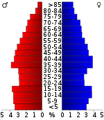
In the county, the population was spread out with 25.40% under the age of 18, 8.30% from 18 to 24, 26.70% from 25 to 44, 23.50% from 45 to 64, and 16.10% who were 65 years of age or older. The median age was 38 years. For every 100 females there were 94.40 males. For every 100 females age 18 and over, there were 91.50 males.
The median income for a household in the county was $31,209, and the median income for a family was $38,179. Males had a median income of $28,199 versus $20,134 for females. The per capita income for the county was $16,056. About 12.20% of families and 16.10% of the population were below the poverty line, including 21.90% of those under age 18 and 13.10% of those age 65 or over.
Government
| Year | GOP | Dem | Others |
|---|---|---|---|
| 2016 | 61.17% 4,849 | 33.51% 2,656 | 5.32% 422 |
| 2012 | 58.40% 4,514 | 38.87% 3,005 | 2.73% 211 |
| 2008 | 57.64% 4,691 | 38.70% 3,149 | 3.66% 298 |
| 2004 | 49.59% 4,009 | 49.26% 3,982 | 1.15% 93 |
| 2000 | 49.00% 3,545 | 48.33% 3,496 | 2.67% 193 |
| 1996 | 31.68% 2,307 | 55.69% 4,055 | 12.63% 920 |
| 1992 | 32.06% 2,719 | 57.75% 4,898 | 10.19% 864 |
| 1988 | 49.35% 4,066 | 50.18% 4,134 | 0.47% 39 |
| 1984 | 57.14% 5,049 | 42.35% 3,742 | 0.51% 45 |
| 1980 | 45.11% 4,145 | 51.13% 4,698 | 3.76% 346 |
| 1976 | 25.23% 2,177 | 74.67% 6,443 | 0.10% 9 |
| 1972 | 58.11% 4,187 | 41.76% 3,009 | 0.12% 9 |
| 1968 | 30.40% 1,973 | 39.44% 2,560 | 30.16% 1,958 |
| 1964 | 36.02% 2,378 | 63.69% 4,205 | 0.29% 19 |
| 1960 | 35.13% 1,685 | 60.47% 2,900 | 4.40% 211 |
| 1956 | 38.22% 1,636 | 61.15% 2,618 | 0.63% 27 |
| 1952 | 40.12% 2,133 | 59.70% 3,174 | 0.19% 10 |
| 1948 | 17.32% 425 | 72.17% 1,771 | 10.52% 258 |
| 1944 | 28.77% 639 | 71.09% 1,579 | 0.14% 3 |
| 1940 | 11.62% 272 | 88.33% 2,067 | 0.04% 1 |
| 1936 | 13.15% 305 | 86.77% 2,013 | 0.09% 2 |
| 1932 | 10.05% 285 | 89.24% 2,530 | 0.71% 20 |
| 1928 | 30.48% 665 | 69.39% 1,514 | 0.14% 3 |
| 1924 | 33.72% 526 | 58.27% 909 | 8.01% 125 |
| 1920 | 40.48% 1,243 | 58.32% 1,791 | 1.20% 37 |
| 1916 | 42.42% 1,032 | 57.58% 1,401 | 0.00% 0 |
| 1912 | 22.15% 527 | 60.32% 1,435 | 17.53% 417 |
| 1908 | 24.04% 818 | 74.43% 2,533 | 1.53% 52 |
| 1904 | 36.80% 937 | 61.74% 1,572 | 1.45% 37 |
| 1900 | 32.72% 805 | 66.46% 1,635 | 0.81% 20 |
| 1896 | 22.40% 656 | 76.99% 2,255 | 0.61% 18 |
Communities
Cities
- Morrilton (county seat)
- Oppelo
- Plumerville
Town
Census-designated place
Unincorporated communities
- Blackwell
- Formosa
- Jerusalem
- Lanty
- Solgohachia
- Springfield
- Cleveland
Townships
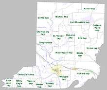
Townships in Arkansas are the divisions of a county. Each township includes unincorporated areas; some may have incorporated cities or towns within part of their boundaries. Arkansas townships have limited purposes in modern times. However, the United States Census does list Arkansas population based on townships (sometimes referred to as "county subdivisions" or "minor civil divisions"). Townships are also of value for historical purposes in terms of genealogical research. Each town or city is within one or more townships in an Arkansas county based on census maps and publications. The townships of Conway County are listed below; listed in parentheses are the cities, towns, and/or census-designated places that are fully or partially inside the township. [13][14]
- Austin
- Bentley (Oppelo)
- Bird
- Catholic Point
- Cedar Falls
- Gregory
- Griffin
- Higgins
- Howard (Menifee, Plumerville)
- Lick Mountain (CDP Center Ridge)
- Martin
- McLaren
- Nichols
- Old Hickory
- Petit Jean
- St. Vincent
- Steele
- Union
- Washington
- Welborn (Morrilton)
- White Eagle
See also
- David J. Sanders, state senator who represents Conway County
- List of lakes in Conway County, Arkansas
- National Register of Historic Places listings in Conway County, Arkansas
- Rick Beck, state representative for Conway and Perry counties; resides in Center Ridge
References
- 1 2 "State & County QuickFacts". United States Census Bureau. Retrieved May 20, 2014.
- ↑ "Find a County". National Association of Counties. Archived from the original on 2011-05-31. Retrieved 2011-06-07.
- ↑ "Centers of Population by State: 2010". United States Census Bureau. Archived from the original on January 3, 2014. Retrieved May 24, 2014.
- ↑ "2010 Census Gazetteer Files". United States Census Bureau. August 22, 2012. Retrieved August 25, 2015.
- ↑ "Population and Housing Unit Estimates". Retrieved June 9, 2017.
- ↑ "U.S. Decennial Census". United States Census Bureau. Archived from the original on May 12, 2015. Retrieved August 25, 2015.
- ↑ "Historical Census Browser". University of Virginia Library. Retrieved August 25, 2015.
- ↑ Forstall, Richard L., ed. (March 27, 1995). "Population of Counties by Decennial Census: 1900 to 1990". United States Census Bureau. Retrieved August 25, 2015.
- ↑ "Census 2000 PHC-T-4. Ranking Tables for Counties: 1990 and 2000" (PDF). United States Census Bureau. April 2, 2001. Retrieved August 25, 2015.
- ↑ Based on 2000 census data
- ↑ "American FactFinder". United States Census Bureau. Archived from the original on 2013-09-11. Retrieved 2011-05-14.
- ↑ "Dave Leip's Atlas of U.S. Presidential Elections". Retrieved November 18, 2016.
- ↑ 2011 Boundary and Annexation Survey (BAS): Conway County, AR (PDF) (Map). U. S. Census Bureau. Archived from the original (PDF) on 2012-10-19. Retrieved 2011-08-19.
- ↑ "Arkansas: 2010 Census Block Maps - County Subdivision". United States Census Bureau. Retrieved May 27, 2014.
External links
- 10th Arkansas Infantry, Local Regiment During the Civil War
- Conway County Sheriff's Office
Places adjacent to Conway County, Arkansas | ||||||||||
|---|---|---|---|---|---|---|---|---|---|---|
| ||||||||||
Municipalities and communities of Conway County, Arkansas, United States | ||
|---|---|---|
| Cities | | |
| Town | ||
| CDP | ||
| Unincorporated communities | ||