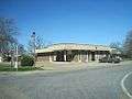
Crawfordsville, Arkansas
| Crawfordsville, Arkansas | |
|---|---|
| City | |
 | |
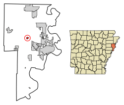 Location of Crawfordsville in Crittenden County, Arkansas. | |
| Coordinates: 35°13′33″N 90°19′35″W / 35.22583°N 90.32639°WCoordinates: 35°13′33″N 90°19′35″W / 35.22583°N 90.32639°W | |
| Country | United States |
| State | Arkansas |
| County | Crittenden |
| Area[1] | |
| • Total | 0.56 sq mi (1.45 km2) |
| • Land | 0.56 sq mi (1.45 km2) |
| • Water | 0.00 sq mi (0.00 km2) |
| Elevation | 220 ft (67 m) |
| Population (2010) | |
| • Total | 479 |
| • Estimate (2017)[2] | 467 |
| • Density | 835.42/sq mi (322.61/km2) |
| Time zone | UTC-6 (Central (CST)) |
| • Summer (DST) | UTC-5 (CDT) |
| ZIP code | 72327 |
| Area code(s) | 870 |
| FIPS code | 05-15940 |
| GNIS feature ID | 0057604 |
Crawfordsville, historically Crawfordville, is a city[3] in Crittenden County, Arkansas, United States. The population was 479 at the 2010 census.[4]
The late Johnnie Taylor, an important figure in both late 1960s and early 1970s Memphis-based soul as well as more recent blues, was born in Crawfordsville.
Fred Smith, a former basketball player for the Harlem Globetrotters and the only Green Party member of the Arkansas House of Representatives, serving from District 50, is a Crawfordsville native and a graduate of Crawfordsville High School.
Dan Young, an attorney at Rose Law Firm (the oldest firm west of the Mississippi), is originally from Crawfordsville.
Geography
Crawfordsville is located near the center of Crittenden County at 35°13′33″N 90°19′35″W / 35.22583°N 90.32639°W (35.225741, -90.326318).[5] U.S. Route 64 passes just north of the town, leading east 8 miles (13 km) to Marion and 19 miles (31 km) to Memphis, Tennessee, and west 9 miles (14 km) to Earle.
According to the United States Census Bureau, Crawfordsville has a total area of 0.58 square miles (1.5 km2), all land.[4]
Demographics
| Historical population | |||
|---|---|---|---|
| Census | Pop. | %± | |
| 1920 | 605 | — | |
| 1930 | 612 | 1.2% | |
| 1940 | 656 | 7.2% | |
| 1950 | 680 | 3.7% | |
| 1960 | 744 | 9.4% | |
| 1970 | 831 | 11.7% | |
| 1980 | 685 | −17.6% | |
| 1990 | 617 | −9.9% | |
| 2000 | 514 | −16.7% | |
| 2010 | 479 | −6.8% | |
| Est. 2017 | 467 | [2] | −2.5% |
| U.S. Decennial Census[6] 2014 Estimate[7] | |||
As of the census[8] of 2000, there were 514 people, 202 households, and 142 families residing in the town. The population density was 451.0/km² (1,167.1/mi²). There were 222 housing units at an average density of 194.8/km² (504.1/mi²). The racial makeup of the town was 49.81% White, 49.42% Black or African American, 0.19% Asian, and 0.58% from two or more races. 1.17% of the population were Hispanic or Latino of any race.
There were 202 households out of which 29.7% had children under the age of 18 living with them, 42.1% were married couples living together, 22.3% had a female householder with no husband present, and 29.7% were non-families. 27.7% of all households were made up of individuals and 13.4% had someone living alone who was 65 years of age or older. The average household size was 2.54 and the average family size was 3.12.
In the town, the population was spread out with 27.0% under the age of 18, 8.8% from 18 to 24, 27.0% from 25 to 44, 23.9% from 45 to 64, and 13.2% who were 65 years of age or older. The median age was 37 years. For every 100 females, there were 89.7 males. For every 100 females age 18 and over, there were 91.3 males.
The median income for a household in the town was $26,518, and the median income for a family was $31,667. Males had a median income of $31,250 versus $19,205 for females. The per capita income for the town was $12,176. About 19.4% of families and 21.1% of the population were below the poverty line, including 27.9% of those under age 18 and 16.4% of those age 65 or over.
Education
Marion School District, including Marion High School, serves Crawfordsville. On July 1, 2004 the Crawfordsville School District consolidated into the Marion School District.[9]
References
| Wikimedia Commons has media related to Crawfordsville, Arkansas. |
- ↑ "2017 U.S. Gazetteer Files". United States Census Bureau. Retrieved Aug 22, 2018.
- 1 2 "Population and Housing Unit Estimates". Retrieved March 24, 2018.
- ↑ Local.Arkansas.gov - Crawfordsville, retrieved September 3, 2012
- 1 2 "Geographic Identifiers: 2010 Demographic Profile Data (G001): Crawfordsville town, Arkansas". U.S. Census Bureau, American Factfinder. Retrieved June 19, 2014.
- ↑ "US Gazetteer files: 2010, 2000, and 1990". United States Census Bureau. 2011-02-12. Retrieved 2011-04-23.
- ↑ "Census of Population and Housing". Census.gov. Archived from the original on May 12, 2015. Retrieved June 4, 2015.
- ↑ "Annual Estimates of the Resident Population for Incorporated Places: April 1, 2010 to July 1, 2014". Retrieved June 4, 2015.
- ↑ "American FactFinder". United States Census Bureau. Archived from the original on 2013-09-11. Retrieved 2008-01-31.
- ↑ "ConsolidationAnnex_from_1983.xls." Arkansas Department of Education. Retrieved on October 13, 2017.
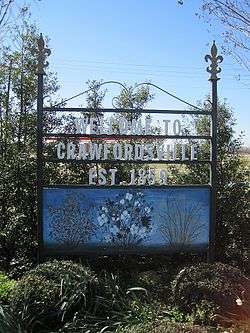
Gallery
External links
Municipalities and communities of Crittenden County, Arkansas, United States | ||
|---|---|---|
| Cities | 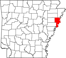 | |
| Towns | ||
| Unincorporated communities | ||