Texel
| Texel | |||
|---|---|---|---|
| Municipality and island | |||
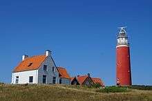
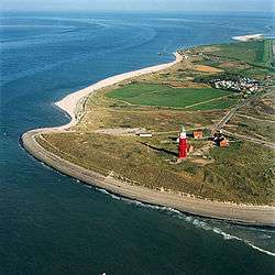 North end of the island with the Eierland Lighthouse in 2015 | |||
| |||
.svg.png) Location in North Holland | |||
| Coordinates: 53°3′N 4°48′E / 53.050°N 4.800°ECoordinates: 53°3′N 4°48′E / 53.050°N 4.800°E | |||
| Country | Netherlands | ||
| Province | North Holland | ||
| Government[1] | |||
| • Body | Municipal council | ||
| • Mayor | Michiel Uitdehaag (D66) | ||
| Area[2] | |||
| • Total | 463.16 km2 (178.83 sq mi) | ||
| • Land | 161.12 km2 (62.21 sq mi) | ||
| • Water | 302.04 km2 (116.62 sq mi) | ||
| Elevation[3] | 2 m (7 ft) | ||
| Population (August 2017)[4] | |||
| • Total | 13,643 | ||
| • Density | 85/km2 (220/sq mi) | ||
| Demonym(s) | Tesselaar, Texelaar | ||
| Time zone | UTC+1 (CET) | ||
| • Summer (DST) | UTC+2 (CEST) | ||
| Postcode | 1790–1797 | ||
| Area code | 0222 | ||
| Website |
www | ||


Texel (Dutch pronunciation: [ˈtɛsəl] (![]()
Name
The name Texel is Frisian, but because of historical sound-changes in Dutch, where all -x- sounds have been replaced with -s- sounds (compare for instance English fox, Frisian fokse, German Fuchs with Dutch vos), the name is typically pronounced Tessel in Dutch.[5]
History
The All Saints' Flood (1170) created the islands of Texel and Wieringen from North Holland.[6] In the 13th century Ada, Countess of Holland was held prisoner on Texel by her uncle William.
Texel received city rights in 1415.
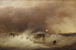
Texel was involved in the Battle of Scheveningen (1653) during the First Anglo-Dutch War and the Battle of Texel (1673) during the Third Anglo-Dutch War.
(Ludolf_Backhuysen%2C_1671).jpg)
Texel is also famous in military history as the only place where a navy was defeated on horseback. Occupying Holland in January 1795, the French continental army learned that the mighty Dutch navy had been frozen into the ice around Texel, so Commandant Louis Joseph Lahure and 128 men rode up to it and demanded surrender. No shots were fired.
In 1797, Texel was involved in the Battle of Camperdown during the French Revolutionary Wars.
During the American Revolution, Texel was used as a haven port for the USS Bonhomme Richard before it sank off the coast of Flamborough Head in Britain in September 1779. In that final action, John Paul Jones defeated and captured the British ship HMS Serapis, which he sailed to Texel for desperately needed repairs. This event further complicated Anglo-Dutch relations.
During the First World War in 1914, the Battle off Texel took place off the coast of Texel.
On the night of 31 August 1940, the sea to the northwest of Texel was the scene of the sinking of two British destroyers and the severe damage of a third by German mines in what is known as the Texel Disaster.
At the end of Second World War in 1945, the Georgian Uprising of Texel took place on the island.
Geography

The municipality is located at 53°3′N 4°48′E / 53.050°N 4.800°E north of the mainland of the province of North Holland and west of the mainland of the province of Friesland. The island of Texel is situated north of the city of Den Helder, northeast of the uninhabited island of Noorderhaaks, which is part of the municipality, and southwest of the island of Vlieland.
The island includes the seven villages De Cocksdorp, De Koog, De Waal, Den Burg, Den Hoorn, Oosterend, and Oudeschild, and the small townships of Bargen, De Nes, Dijkmanshuizen, Driehuizen, Harkebuurt, 't Horntje, Midden-Eierland, Molenbuurt, Nieuweschild, Noorderbuurt, Ongeren, Oost, Spang, Spijkdorp, Tienhoven, Westermient, Zevenhuizen, and Zuid-Eierland.
The island of Texel was originally made up of two islands, Texel proper to the south and Eierland to the northeast, which were connected by shoals. In the early seventeenth century, the islands were connected by a dyke to keep the North Sea from ravaging the coastal areas of Texel proper. In the mid-nineteenth century a polder completed the northern half of the island. Today, Texel forms the largest natural barrier between the North Sea and the Wadden Sea.
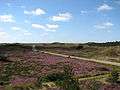
The dune landscape along the western coast of the island is protected as Dunes of Texel National Park.
Landscape
The dune landscape on Texel is a unique habitat for wildlife. Notable areas include De Slufter, where the tide comes in and meets the dunes, forming a marshy environment rich in both fauna and flora. Texel is known for its wildlife, particularly in winter, when birds of prey and geese take up residence. About one third of Texel is a protected nature reserve. A wetland called Utopia has been designed for birds to nest in.[7]


Climate
| Climate data for Texel | |||||||||||||
|---|---|---|---|---|---|---|---|---|---|---|---|---|---|
| Month | Jan | Feb | Mar | Apr | May | Jun | Jul | Aug | Sep | Oct | Nov | Dec | Year |
| Record high °C (°F) | 13.7 (56.7) |
14.9 (58.8) |
20.5 (68.9) |
27.9 (82.2) |
31.0 (87.8) |
31.7 (89.1) |
34.6 (94.3) |
33.8 (92.8) |
32.6 (90.7) |
24.8 (76.6) |
17.7 (63.9) |
15.3 (59.5) |
34.6 (94.3) |
| Average high °C (°F) | 5.5 (41.9) |
5.5 (41.9) |
8.3 (46.9) |
11.7 (53.1) |
15.4 (59.7) |
18 (64) |
20.3 (68.5) |
20.6 (69.1) |
17.9 (64.2) |
14 (57) |
9.7 (49.5) |
6.4 (43.5) |
12.8 (54.9) |
| Average low °C (°F) | 1.2 (34.2) |
0.8 (33.4) |
2.8 (37) |
5 (41) |
8.6 (47.5) |
11.3 (52.3) |
13.8 (56.8) |
14 (57) |
11.7 (53.1) |
8.5 (47.3) |
4.9 (40.8) |
2 (36) |
7.1 (44.7) |
| Record low °C (°F) | −18.8 (−1.8) |
−18.5 (−1.3) |
−14.5 (5.9) |
−4.8 (23.4) |
−2.1 (28.2) |
1.5 (34.7) |
5.2 (41.4) |
5.6 (42.1) |
3.0 (37.4) |
−4.6 (23.7) |
−10.8 (12.6) |
−12.3 (9.9) |
−18.8 (−1.8) |
| Average precipitation mm (inches) | 66.2 (2.606) |
44.4 (1.748) |
52.4 (2.063) |
33.7 (1.327) |
45 (1.77) |
54.1 (2.13) |
59.8 (2.354) |
76.8 (3.024) |
83.7 (3.295) |
95.9 (3.776) |
83.5 (3.287) |
69.8 (2.748) |
765.3 (30.128) |
| Mean monthly sunshine hours | 64.1 | 91.1 | 134.8 | 194.2 | 235.2 | 219 | 228.2 | 208.2 | 148 | 114.2 | 63.1 | 51 | 1,751.1 |
| Source #1: [8] | |||||||||||||
| Source #2: [9] | |||||||||||||
Economy
The tourism industry forms a substantial part of the economy in Texel. Approximately 70% of activities on Texel are in some way related to tourism. Popular forms of tourism on Texel include cycling, walking, swimming and horse riding.
Local government
The municipal council of Texel consists of 15 seats, which are divided as follows (from the most recent election results in 2018 ):
- Texels Belang, 4 seats
- VVD, 3 seats
- PvdA, 2 seats
- GroenLinks, 2 seats
- CDA, 2 seats
- D66, 1 seat
- Texel 2010, 1 seat
Transport
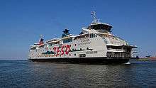
Transport around the island is typically by bicycle, bus (Texelhopper) or car. Texel has an extensive cycle path network. Transport to Texel is usually by ferry (Royal TESO), from Den Helder, or by air via Texel International Airport. The ferry Texelstroom uses 80% compressed natural gas.[10]
See also
References
- ↑ "B&W samenstelling en portefeuilles" [Mayor and aldermen members and tasks] (in Dutch). Gemeente Texel. Archived from the original on 27 July 2014. Retrieved 22 March 2014.
- ↑ "Kerncijfers wijken en buurten" [Key figures for neighbourhoods]. CBS Statline (in Dutch). CBS. 2 July 2013. Retrieved 12 March 2014.
- ↑ "Postcodetool for 1791AT". Actueel Hoogtebestand Nederland (in Dutch). Het Waterschapshuis. Retrieved 22 March 2014.
- ↑ "Bevolkingsontwikkeling; regio per maand" [Population growth; regions per month]. CBS Statline (in Dutch). CBS. 27 October 2017. Retrieved 27 October 2017.
- ↑ Donaldson, Bruce C. (1983). Dutch: A Linguistic History of Holland and Belgium. Leiden: Martinus Nijhoff. p. 151. ISBN 9789024791668.
- ↑ Ley, Willy (October 1961). "The Home-Made Land". For Your Information. Galaxy Science Fiction. pp. 92–106.
- ↑ Utopia voor vogels
- ↑ "Klimaatatlas| KNMI". knmi.nl. Retrieved 8 March 2015.
- ↑ "www.weergegevens.nl". Retrieved 9 March 2015.
- ↑ "Norske Umoe har levert verdens første trykktanker i kompositt til skip". Teknisk Ukeblad. 30 January 2017. Retrieved 31 January 2017.
External links
| Wikimedia Commons has media related to Texel. |
- Official website


Places adjacent to Texel | ||||||||||
|---|---|---|---|---|---|---|---|---|---|---|
| ||||||||||

| West Frisian Islands (Netherlands) |
|  | |||||
|---|---|---|---|---|---|---|---|
| East Frisian Islands (Germany) |
| ||||||
| Heligoland Bight (Germany) | |||||||
| North Frisian Islands (Germany) |
| ||||||
| Danish Wadden Sea Islands (Denmark) |
| ||||||