Huizen
| Huizen | |||
|---|---|---|---|
| Municipality | |||
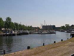 Harbour of Huizen | |||
| |||
.svg.png) Location in North Holland | |||
| Coordinates: 52°18′N 5°15′E / 52.300°N 5.250°ECoordinates: 52°18′N 5°15′E / 52.300°N 5.250°E | |||
| Country | Netherlands | ||
| Province | North Holland | ||
| Government[1] | |||
| • Body | Municipal council | ||
| • Mayor | Sicko Heldoorn (acting) (PvdA) | ||
| Area[2] | |||
| • Total | 23.32 km2 (9.00 sq mi) | ||
| • Land | 15.82 km2 (6.11 sq mi) | ||
| • Water | 7.50 km2 (2.90 sq mi) | ||
| Elevation[3] | 3 m (10 ft) | ||
| Population (August 2017)[4] | |||
| • Total | 41,418 | ||
| • Density | 2,618/km2 (6,780/sq mi) | ||
| Demonym(s) | Huizenaar, Huizer | ||
| Time zone | UTC+1 (CET) | ||
| • Summer (DST) | UTC+2 (CEST) | ||
| Postcode | 1270–1277 | ||
| Area code | 035 | ||
| Website |
www | ||


Huizen [ˈɦœy̯zə(n)] (![]()
The name "Huizen" is Dutch for "houses" and this usage has been linked to the belief that the first stone houses in the region appeared here. Huizen is part of the metropolitan area of Amsterdam.
History
Huizen originally was an agricultural village, about 2 kilometres from the sea. During wintertime the farmers went fishing. Later on it developed to coastal village, with a thriving fishing industry, which was stimulated by building the harbor about 1850. After the damming of the Zuider Zee by the Afsluitdijk in 1932, the old sea was degraded to a mere freshwater lake, and economical activities shifted towards industry and commerce.
In the 1960s the town was designated to build substantially large residential areas, to overcome the housing shortage in the region. From then on, the village took on an influx of people and grew rapidly.
Where the Phohi-flat now stands in Huizen was, before World War II, the site of a large transmitter intended for contacting the Dutch East Indies, some 12.000 km away.
A post mill that stood in Huizen was dismantled in 1916. It was re-erected in 1919 at the Netherlands Open Air Museum, Arnhem, Gelderland.
Topography
Huizen is part of the area 'Het Gooi'. 'Het Gooi' is known in the Netherlands as the home of the rich and famous.
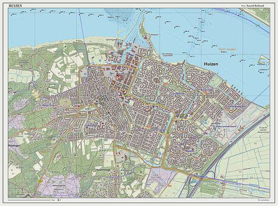
Dutch Topographic map of Huizen (town), March 2014.
Local government
The municipal council of Huizen consists of 27 seats, which are divided as follows:
- VVD - 5 seats
- CDA - 5 seats
- D66 - 4 seats
- Dorpsbelangen Huizen - 3 seats
- PvdA - 3 seats
- GroenLinks - 2 seats
- ChristenUnie - 2 seats
- Leefbaar Huizen - 2 seats
- SGP - 1 seat
Transport
With its population of almost 42,000, Huizen is one of the larger towns without railway connection. On a national level, it's preceded by Drachten and Oosterhout.
References
- ↑ "Burgemeester mr. A.Ph. Hertog" (in Dutch). Gemeente Huizen. Retrieved 11 March 2014.
- ↑ "Kerncijfers wijken en buurten" [Key figures for neighbourhoods]. CBS Statline (in Dutch). CBS. 2 July 2013. Retrieved 12 March 2014.
- ↑ "Postcodetool for 1276KB". Actueel Hoogtebestand Nederland (in Dutch). Het Waterschapshuis. Archived from the original on 21 September 2013. Retrieved 11 March 2014.
- ↑ "Bevolkingsontwikkeling; regio per maand" [Population growth; regions per month]. CBS Statline (in Dutch). CBS. 27 October 2017. Retrieved 27 October 2017.
External links

- Official website
