Hoorn
| Hoorn, Netherlands | |||
|---|---|---|---|
| Municipality | |||
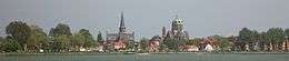 .jpg) 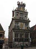 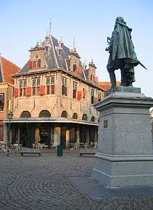    From top down, left to right: skyline of Hoorn; Halve Maen; West-Frisian Museum, Roode Steen square; Hoofdtoren, Hoorn Central Station, city canal | |||
| |||
.svg.png) Location in North Holland | |||
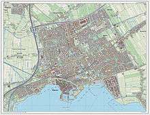
| Coordinates: 52°39′N 5°4′E / 52.650°N 5.067°ECoordinates: 52°39′N 5°4′E / 52.650°N 5.067°E | |||
| Country | Netherlands | ||
| Province | North Holland | ||
| Government[1] | |||
| • Body | Municipal council | ||
| • Mayor | Jan Nieuwenburg (PvdA) | ||
| Area[2] | |||
| • Total | 53.25 km2 (20.56 sq mi) | ||
| • Land | 20.25 km2 (7.82 sq mi) | ||
| • Water | 33.00 km2 (12.74 sq mi) | ||
| Elevation[3] | −1 m (−3 ft) | ||
| Population (August 2017)[4] | |||
| • Total | 72,707 | ||
| • Density | 3,590/km2 (9,300/sq mi) | ||
| Time zone | UTC+1 (CET) | ||
| • Summer (DST) | UTC+2 (CEST) | ||
| Postcode | 1620–1628, 1689, 1695 | ||
| Area code | 0229 | ||
| Website |
www | ||


Hoorn [ˈɦoːr(ə)n] (![]()
Cape Horn, the most southerly point of the Americas, was named after the town by Willem Schouten, who navigated the cape in 1616.
The Hoorn Islands of the French overseas collectivity of Wallis and Futuna in Oceania are also named after this city.
Etymology
The origin of the name Hoorn, even in old spelling Hoern(e) or Hoirne, is surrounded in myths. Hoorn's name, according to Old Frisian legends, is derived from the stepson of King Redbad (Radboud), called Hornus. Another story about the origin of the name is that it is derived from a sign depicting a post horn in an early 14th-century hanging outside one of the establishments situated on the Roode Steen Square. A third version says that the name was derived from the horn shape of one of its first ports. The author of the 'Origo Civitatis Hornensis' (see page. 256, 'Uit de schemer van Hoorns verleden') assumes that name Hoorn was derived from Damphoorn. Damphoorn is the medieval name for a weed that could be made into whistles, which grew in abundance in the area outside the dykes of Hoorn. Chronicler Velius rejects this statement because there are no old historical entries that Hoorn was called Damphoorn. He wrote: The name was from the start Hoorn: not (against better judgement) derived from the weed Damphoorn, as the current sentiment holds (De name was van eersten af Hoorn: niet (behoudens beter oordeel) van het kruyt Damphoorn, als t'ghemeyne ghevoelen van noch heden hout). Velius also rejects the assertion that the name's origin is Dampter Horn: a neighbourhood of the village Dampten, which flooded and had fallen into disuse.
The name is most probably derived from Hornicwed, a name that is popping up in early mediaeval documents. The medieval meaning of hornic is 'corner', with wed or wedor being the medieval word for water. Many places and neighbourhoods in the Netherlands are called, even today; Heurne, Huurne and Horn. Hornicwed would therefore refer to the location of a corner on the coastline: the location of Hoorn at the Zuiderzee. We see hornic in the meaning of 'corner' also reflected in another municipality in the mediaeval County of Holland: Uithoorn, meaning uithoek, which refers to a certain occupied area (or corner) at some distance.
It is also sometimes argued that hornic refers to a corner in a dike, but this raises doubts: the coast of the Zuiderzee was originally farther away from Hoorn compared to the present day: the Westfriese Omringdijk ran, originating from the West, in a straight line to Schardam and in front of this dyke there were then low-lying tracts of land, where the village of Dampten was located according to Velius. This area was abandoned and flooded after 1391, following the abandonment of the old dyke. A new dyke was built farther inland, resulting in a bay which is now the Hoornse Hop. Hoorn was already in existence then.
History
| Historical population | ||
|---|---|---|
| Year | Pop. | ±% p.a. |
| 1398 | 3,800 | — |
| 1514 | 5,400 | +0.30% |
| 1550 | 8,000 | +1.10% |
| 1622 | 14,139 | +0.79% |
| 1632 | 13,500 | −0.46% |
| 1732 | 12,000 | −0.12% |
| 1795 | 9,551 | −0.36% |
| Source: Lourens & Lucassen 1997, pp. 62–63 | ||
Founded in 716, Hoorn rapidly grew to become a major harbour town. During Holland's 'Golden Age' (or 'Golden Century'), Hoorn was an important home base for the Dutch East India Company (VOC) and a very prosperous centre of trade. The Hoorn fleet plied the seven seas and returned laden with precious commodities. Exotic spices such as pepper, nutmeg, cloves, and mace were sold at vast profits. With their skill in trade and seafaring, sons of Hoorn established the town's name far and wide. Jan Pieterszoon Coen (1587–1629) is famous for his violent raids in Dutch Indies (now Indonesia), where he "founded" the city of Batavia in 1619 (now Jakarta). He has a big statue on the Rode Steen square in the center of Hoorn.
In 1618 Willem Bontekoe (1587–1657) undertook his first and only voyage for the VOC. His story of his travel and hardship found its way into the history books when he published his adventures in 1646 under the title Journael ofte gedenckwaerdige beschrijvinge van de Oost-Indische reyse van Willem Ysbrantsz. Bontekoe van Hoorn, begrijpende veel wonderlijcke en gevaerlijcke saecken hem daer in wedervaren ('Journal, or memorable description, of the East-Indian voyage of Willem Ysbrantz. Bontekoe of Hoorn, comprising many wondrous and dangerous things experienced by him'). In 1616, the explorer Willem Corneliszoon Schouten braved furious storms as he rounded the southernmost tip of South America. He named it Kaap Hoorn (Cape Horn) in honour of his home town.[5]
Hoorn's fortunes declined somewhat in the eighteenth century. The prosperous trading port became little more than a sleepy fishing village on the Zuiderzee. Following Napoleonic occupation, there was a period during which the town gradually turned its back on the sea. It developed to become the market for the entire West Frisian agricultural region. Stallholders and shopkeepers devoted themselves to trading in dairy produce and seeds. When the railway and metalled roads came to Hoorn in the late nineteenth century, the town rapidly took its rightful place as a conveniently located and readily accessible centre in the network of towns and villages which make up the province of Noord-Holland. In 1932, the Afsluitdijk, or Great Enclosing Dyke, was completed, and Hoorn was no longer a seaport.
The years after the Second World War saw a period of renewed growth. At the centre of a flourishing horticultural region, Hoorn developed an extremely varied economy. During the 1960s, Hoorn was designated an 'overflow' city to relieve pressure on the overcrowded Randstad region. Thousands of people swapped their cramped little apartments in Amsterdam for a family house with garden in one of Hoorn's modern new developments.
On 26 March 2007, Hoorn celebrated 650 years as a city: in 1357 Hoorn was awarded city rights by the Count of Holland after a lump sum payment of 1500 schilden to the Count.
Notable Buildings
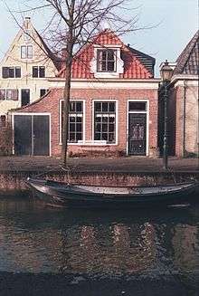
Hoorn has a very high number of surviving 17th and 18th century houses, especially north of the harbour area, adding much to the character of the area. Other notable buildings include:
- The main protestant church on Kerkplein, converted to shops and community uses in 1997[6] but currently (2018) closed.
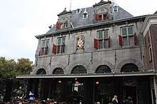
- The Oude Waegh (17th century weigh-house) at the junction of Grote Oost and the main town square
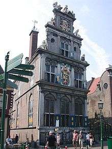
- The 15th century Hoofdtoren, the old harbour control building
- A very fine line of 17th century houses and original shop-fronts on the harbour edge at Hoofd
- Twees Huys (1620) on Achterstraat
Neighbourhoods
Hoorn contains 13 neighbourhoods:
- Binnenstad
- Venenlaankwartier
- Hoorn-Noord
- Grote Waal
- Risdam-Zuid
- Risdam-Noord
- Nieuwe Steen
- Zwaag
- Westerblokker
- Kersenboogerd-Noord
- Kersenboogerd-Zuid
- Hoorn 80
- Bangert en Oosterpolder
Museums
- Museumstoomtram Hoorn-Medemblik
- Westfries Museum
- Museum van de 20e Eeuw on Oostereiland
Local government
The municipal council of Hoorn consists of 35 seats, which are divided as follows:
Railway connections
Hoorn is connected to the Dutch railway network, and has two stations: Hoorn and Hoorn Kersenboogerd. Also, it is the starting point of the historical railway between Hoorn and Medemblik.
Notable residents
- Stephan van den Berg (born 1962) windsurfer, world champion and first Olympic Gold medalist Men's Windglider
- Jan Pieterszoon Coen (1587-1629), Governor-General of the Dutch East Indies
- Martinus Houttuyn (1720-1798), naturalist and publisher
- Hadrianus Junius (1511-1575), aka Adriaen de Jonghe, physician, classical scholar, translator, lexicographer, antiquarian, historiographer, emblematist, school rector, and Latin poet.
- Jacob Rotius (11 September 1644 – 1681), Golden Age flower painter
- Jan Albertsz Rotius (1624-1666), Golden Age portrait painter, and father of the painter Jacob
- Ernesto Hoost (born July 11, 1965), four-time K-1 World Champion
- Willem Bontekoe (1587-1657), sea captain and explorer
Twin cities
The City of Hoorn has a twin city status with:
See also
References
- ↑ "Samenstelling" [Members] (in Dutch). Gemeente Hoorn. Retrieved 10 March 2014.
- ↑ "Kerncijfers wijken en buurten" [Key figures for neighbourhoods]. CBS Statline (in Dutch). CBS. 2 July 2013. Retrieved 12 March 2014.
- ↑ "Postcodetool for 1625HV". Actueel Hoogtebestand Nederland (in Dutch). Het Waterschapshuis. Archived from the original on 21 September 2013. Retrieved 10 March 2014.
- ↑ "Bevolkingsontwikkeling; regio per maand" [Population growth; regions per month]. CBS Statline (in Dutch). CBS. 27 October 2017. Retrieved 27 October 2017.
- ↑ http://www.netherlands-tourism.com/hoorn/
- ↑ New York Times 10 March 1997
- ↑ "Malacca, a Dutch conquest forgotten". Malaysian Dutch Descendants Project. Retrieved 2013-07-09.
- ↑ "Twin Cities plan will boost Malacca". New Straits Times. Retrieved 2013-07-09.
- ↑ "Bandar Kembar Melaka, Hoorne" (PDF) (in Malay). Pustaka Perdana Library. Retrieved 2013-07-09.
Literature
- Lourens, Piet; Lucassen, Jan (1997). Inwonertallen van Nederlandse steden ca. 1300–1800. Amsterdam: NEHA. ISBN 9057420082.
External links
| Wikimedia Commons has media related to Hoorn, North Holland. |
| Wikisource has the text of the 1921 Collier's Encyclopedia article Hoorn. |
Places adjacent to Hoorn | |
|---|---|
