Edam-Volendam
| Edam-Volendam | |||
|---|---|---|---|
| Municipality | |||
 Aerial view of Edam-Volendam | |||
| |||
.PNG) Location in North Holland | |||
| Coordinates: 52°30′N 5°3′E / 52.500°N 5.050°ECoordinates: 52°30′N 5°3′E / 52.500°N 5.050°E | |||
| Country | Netherlands | ||
| Province | North Holland | ||
| Government[1] | |||
| • Body | Municipal council | ||
| • Mayor | Lieke Sievers | ||
| Area[2] | |||
| • Total | 24.78 km2 (9.57 sq mi) | ||
| • Land | 16.31 km2 (6.30 sq mi) | ||
| • Water | 8.47 km2 (3.27 sq mi) | ||
| Elevation[3] | −1 m (−3 ft) | ||
| Population (August 2017)[4] | |||
| • Total | 35,870 | ||
| • Density | 2,199/km2 (5,700/sq mi) | ||
| Time zone | UTC+1 (CET) | ||
| • Summer (DST) | UTC+2 (CEST) | ||
| Postcode | 1130–1135, 1470–1477 | ||
| Area code | 0299 | ||
| Website |
www | ||


Edam-Volendam (![]()
Edam-Volendam has about 35,000 inhabitants and covers an area of about 80 km².
Local government
The municipal council of Edam-Volendam consists of 25 seats, which are divided as follows (2016):
- Lijst Kras - 6 seats
- Volendam '80 - 4 seats
- CDA - 4 seats
- Zeevangs Belang - 4 seats
- VVD - 3 seats
- GroenLinks - 3 seats
- PvdA - 1 seat
Topography
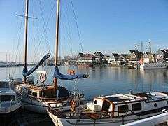
The harbour at Volendam

Dutch Topographic map of the municipality of Edam-Volendam, January 2016.
References
- ↑ "Gegevens collegeleden" [Data of members of the board] (in Dutch). Gemeente Edam-Volendam. Archived from the original on 4 March 2014. Retrieved 3 March 2014.
- ↑ "Kerncijfers wijken en buurten" [Key figures for neighbourhoods]. CBS Statline (in Dutch). CBS. 2 July 2013. Retrieved 12 March 2014.
- ↑ "Postcodetool for 1132KN". Actueel Hoogtebestand Nederland (in Dutch). Het Waterschapshuis. Retrieved 3 March 2014.
- ↑ "Bevolkingsontwikkeling; regio per maand" [Population growth; regions per month]. CBS Statline (in Dutch). CBS. 27 October 2017. Retrieved 27 October 2017.
External links

- Official website
Places adjacent to Edam-Volendam | ||||||||||
|---|---|---|---|---|---|---|---|---|---|---|
| ||||||||||

This article is issued from
Wikipedia.
The text is licensed under Creative Commons - Attribution - Sharealike.
Additional terms may apply for the media files.