Zaanstad
| Zaanstad | |||
|---|---|---|---|
| Municipality | |||
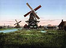
 Windmill Het Pink | |||
| |||
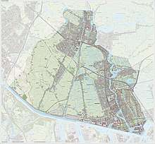
.svg.png) Location in North Holland | |||
| Coordinates: 52°26′N 4°49′E / 52.433°N 4.817°ECoordinates: 52°26′N 4°49′E / 52.433°N 4.817°E | |||
| Country | Netherlands | ||
| Province | North Holland | ||
| Established | 1 January 1974 | ||
| Government[1] | |||
| • Body | Municipal council | ||
| • Mayor | Jan Hamming (PvdA) | ||
| Area[2] | |||
| • Total | 83.24 km2 (32.14 sq mi) | ||
| • Land | 73.88 km2 (28.53 sq mi) | ||
| • Water | 9.36 km2 (3.61 sq mi) | ||
| Elevation[3] | 1 m (3 ft) | ||
| Population (August 2017)[4] | |||
| • Total | 154,442 | ||
| • Density | 2,090/km2 (5,400/sq mi) | ||
| Time zone | UTC+1 (CET) | ||
| • Summer (DST) | UTC+2 (CEST) | ||
| Postcode | Parts of 1500 range | ||
| Area code | 075 | ||
| Website |
www | ||


Zaanstad [ˈzaːnstɑt] (![]()
Population centres
The municipality of Zaanstad is also mainly a conurbation itself and consists of the following cities, towns, villages and/or districts: Assendelft, Koog aan de Zaan, Krommenie, Westzaan, Wormerveer, Zaandam, Zaandijk. However, being surrounded by countryside and due to its relatively protracted shape that follows the river Zaan, a rural atmosphere is always nearby.
Railway stations in Zaanstad
- Koog aan de Zaan railway station (formerly Koog Bloemwijk)
- Krommenie-Assendelft railway station
- Wormerveer railway station
- Zaandam railway station
- Zaandam Kogerveld railway station
- Zaandijk Zaanse Schans railway station (formerly Koog-Zaandijk)
Local government
The municipal council of Zaanstad consists of 39 seats, which are divided as follows:[5]
PvdA (8 seats), VVD (7), ZOG (4), SP (3), GroenLinks (3), D66 (3), CDA (2), TROTS (2), ROSA (2), ChristenUnie (1), Democratisch Zaanstad (1), POV (1), PvdIJ (1), Dissels (1).
Notable tourist attractions
Notable people from Zaanstad
- Ali B (born 1981), Dutch rap musician
- Han Bennink (born 1942), jazz drummer and percussionist
- Emine Bozkurt (born 1967), politician
- Hanneke Ippisch (1925–2012), member of the Dutch resistance in World War II
- Floris Takens (1940–2010), mathematician
- Piet Zwart (1885–1977), graphic designer, industrial designer and typographer
International relations
Twin towns – sister cities
Zaanstad is twinned with:
References
- ↑ "Burgemeester mr. G.H. Faber (PvdA)" [Mayor G.H. Faber (PvdA)] (in Dutch). Gemeente Zaanstad. Retrieved 6 March 2014.
- ↑ "Kerncijfers wijken en buurten" [Key figures for neighbourhoods]. CBS Statline (in Dutch). CBS. 2 July 2013. Retrieved 12 March 2014.
- ↑ "Postcodetool for 1506MZ". Actueel Hoogtebestand Nederland (in Dutch). Het Waterschapshuis. Retrieved 6 March 2014.
- ↑ "Bevolkingsontwikkeling; regio per maand" [Population growth; regions per month]. CBS Statline (in Dutch). CBS. 27 October 2017. Retrieved 27 October 2017.
- ↑ "www.zaanstad.nl/bpo/raad/raadsleden/". Archived from the original on November 21, 2012.
External links

- Official website
Places adjacent to Zaanstad | |
|---|---|
