Hurvat Itri
| Hebrew: חורבת עתרי, Arabic: Umm Suweid | |
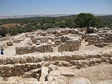 Archaeological remains at Hurvat Itri | |
 Shown within Mandatory Palestine  Hurvat Itri (Israel) | |
| Location |
|
|---|---|
| History | |
| Periods | Second Temple era |
| Site notes | |
| Archaeologists | Boaz Zissu, Amir Ganor |
| Public access | Open year round |
| "Horvat 'Ethri" is how the excavator, Boaz Zissu, transliterates the Hebrew name | |
Coordinates: 31°38′58″N 34°58′19″E / 31.6494720°N 34.9720070°E Horvat 'Ethri (Hebrew: חורבת עתרי; alt. spellings: Hurvat Itri, Ethri, Atari), Hebrew for "Ethri Ruins", Arabic name: Umm Suweid ("mother of the buckthorns"), is a sprawling archaeological site that features the remains of a now partially restored Jewish village which dates back to the Second Temple period. The site sits upon an elevation of 406 metres (1,332 ft) above sea level, wherein are preserved an ancient synagogue, wine presses, cisterns, ritual baths and stone ossuaries, as well as an underground system of public hiding places. The site is located in modern-day Israel and is situated in the Judean Hills, southeast of Bet Shemesh, within the Adullam-France Park – c. 35 kilometers (22 mi) southwest of Jerusalem, 5 kilometers (3.1 mi) southeast of the Elah Valley and 8 kilometers (5.0 mi) northeast of Beth Guvrin. The site stands out among other archaeological sites because of its formidable defensive walls, with massive stones, which led Israeli archaeologist, Boaz Zissu, to believe that it may have been one of the fifty strongholds in Judea destroyed by Hadrian during the Bar Kokhba revolt.
Name
Formerly known in Arabic as Umm Suweid ("mother of the buckthorns"), the Modern Hebrew name of the site was only applied in March 2001 by the Israel Official Names Commission, after a team of IAA archaeologists discovered an ostracon bearing the name "Ethri," thought to be a reference to the a town described by Josephus and whom he names "Caphethra" – likely a Greek corruption of the Hebrew name Kfar Ethra, "Ethra Villge".[1]
History
The Judean Hills were populated by Hebrew tribes during the 1st millennium BCE and then became increasingly densely populated up to the 1st century CE. At the time of the Great Revolt (66 CE – 74 CE) of the Jews against the Roman rulers, the Romans took over the hills and destroyed many of the villages and towns. Despite the revolt Jewish people returned and rebuilt their villages. Some six decades later came a second revolt known as the Bar Kokhba Revolt, which lasted from 132–135 CE, during which the Jews attacked the Romans using underground tunnels and made widespread use of hideout caves. In the end Jewish population was beaten and their villages and towns were destroyed.[2][3][4]

Archaeology
Archaeological findings at the site reveal that its inhabitants had several sources of income, namely, a columbarium facility for breeding doves and producing fertilizer, and loom and spindle weights for spinning and weaving. However, its numerous wine presses suggest that the town's inhabitants were engaged in viniculture. Archaeological artifacts and ruins have been found dating back to the Persian, Hellenistic and Early Roman periods.[5] According to Finish scholar, Aapeli Saarisalo, who visited the site in the earlier 20th-century, the village was settled as late as the Byzantine and Early Arab period.[6]
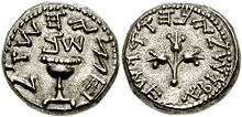
Of special interest were the discoveries of small coins from the second and third year of the First Jewish Revolt, particularly, a silver half-shekel coin from the 3rd year of the revolt, upon which are embossed the words "Half-Shekel" in paleo-Hebrew (Hebrew: חצי השקל), and having a silver content of 6.87 grams, discovered in an area of the site known as "complex XIV," and a bronze coin with a date-palm tree and the inscription, "El'azar the Priest," on its obverse side, and a cluster of grapes with the inscription, "Year One of the Freedom of Israel," on its reverse side.[7][8]
Gallery
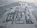 Recreation of what some of the structures may have looked like.
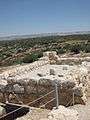 Archaeological remains.
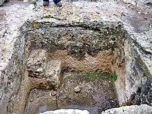
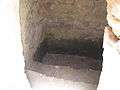 Ancient Jewish Mikveh uncovered at the site.
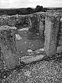 Ruin of Hurvat Itri
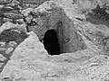 Entrance to cavern
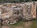 Entranceway to ruined house
 Sealed entrance in Hurvat Itri
 Ruins of Hurvat Itri
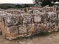 Stone wall
 Black & white photograph of ruins in Hurvat Itri, Judean mountains
.jpg) View of Itri ruins
View of Itri ruins
See also
References
- ↑ See Josephus, The Jewish War, 4.9.9, where the name is rendered in Greek as Κάφεθρα, believed to be a corruption of "Kfar Ethra". Cf. Boaz Zissu and Amir Ganor, Horvat 'Ethri — A Jewish Village from the Second Temple Period and the Bar Kokhva Revolt in the Judean Foothills, Journal of Jewish Studies, vol. LX, no. 1, Spring 2009, p. 90, note 1.
- ↑ "Raiders of the lost synagogue: Ancient village opens to keep grave robbers away". JWeekly.com. 28 May 2004.
- ↑ William M. Schniedewind, A Social History of Hebrew: Its Origins Through the Rabbinic Period, Yale University Press, 2013, ISBN 9780300199109
- ↑ Shai Mahelel, Hiking in Israel, on Ynetnews via DailyJews.com, 10 November 2005
- ↑ Boaz Zissu & Amir Ganor, Horvat Ethri — A Jewish Village from the Second Temple Period and the Bar Kokhba Revolt in the Judean Foothills, Journal of Jewish Studies 60 (1), Oxford Centre for Hebrew and Jewish Studies, London 2009, pp. 92—96.
- ↑ Aapeli Saarisalo, "Topographical Researches in the Shephelah", in: The Journal of the Palestine Oriental Society, vol. XI, Jerusalem 1931, pp. 16, 20
- ↑ Boaz Zissu & Amir Ganor, Horvat Ethri — A Jewish Village from the Second Temple Period and the Bar Kokhba Revolt in the Judean Foothills, Journal of Jewish Studies 60 (1), Oxford Centre for Hebrew and Jewish Studies, London 2009, pp. 96; 118.
- ↑ Boaz Zissu and Amos Kloner, Rock-Cut Hiding Complexes from the Roman Period in Israel (expanded and improved version of article published by Kloner and Zissu 2009), fig. 28 on p. 17 in pdf.
External links
- "Village Razed, Revel Beheaded" - Biblical Archaeology Review (2007)
- Horbat Ethri: Final Report, by Boaz Zissu
- Ethri
- Village of Itri, on israelandyou.com, with captioned slide show and how-to-get-there instructions
| Wikimedia Commons has media related to Hurvat Itri. |