Tarra Fault
| Tarra Fault | |
|---|---|
| Falla de Tarra | |
 | |
| Etymology | Tarra River |
| Named by | Page |
| Year defined | 1986 |
| Country |
|
| Region | Andean |
| State | Norte de Santander |
| Characteristics | |
| Range | Eastern Ranges, Andes |
| Part of | Andean thrust faults |
| Length | 26.8 km (16.7 mi) |
| Strike | 007.6 ± 8 |
| Dip | West |
| Dip angle | High |
| Displacement | <0.2 mm (0.0079 in)/yr |
| Tectonics | |
| Plate | North Andean |
| Status | Active |
| Type | Thrust fault |
| Movement | Reverse |
| Age | Quaternary |
| Orogeny | Andean |
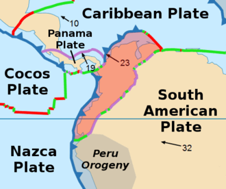
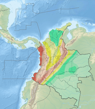
The Tarra Fault (Spanish: Falla de Tarra) is a thrust fault in the department of Norte de Santander in Colombia. The fault has a total length of 26.8 kilometres (16.7 mi) and runs along an average north-northeast to south-southwest strike of 007.6 ± 8 in the Eastern Ranges of the Colombian Andes.
Etymology
The fault is named after the Tarra River.[1]
Description
The Tarra Fault is located northwest of the city of Cúcuta and Las Mercedes Fault. The fault thrusts Precambrian and Paleozoic rocks over Cretaceous rocks. It has a very pronounced morphologic expression along the base of the mountain front through the western side of the Tarra valley. The strong topographic signature of the scarp suggests, according to Page (1986), that the fault is as active as other known Quaternary faults in the region.[1] The fault runs from El Tarra in the north to Hacari in the south.[2][3]
See also
References
Bibliography
- Paris, Gabriel; Michael N. Machette; Richard L. Dart, and Kathleen M. Haller. 2000. Map and Database of Quaternary Faults and Folds in Colombia and its Offshore Regions, 1–66. USGS. Accessed 2017-09-18.
Maps
- Paris, Gabriel; Michael N. Machette; Richard L. Dart, and Kathleen M. Haller. 2000. Map of Quaternary Faults and Folds of Colombia and Its Offshore Regions, 1. USGS. Accessed 2017-09-18.
- Daconte, Rommel; Rosalba Salinas; José María Royero; Jairo Clavijo; Alfonso Arias; Luz S. Carvajal; Martín E. López; Leonidas Angarita, and Hernando Mendoza. 1980. Plancha 66 - Miraflores - 1:100,000, 1. INGEOMINAS. Accessed 2017-06-06.
- Daconte, Rommel, and Rosalba Salinas. 1980. Plancha 76 - Ocaña - 1:100,000, 1. INGEOMINAS. Accessed 2017-06-06.
Further reading
- Page, W.D. 1986. Seismic geology and seismicity of Northwestern Colombia, 1–200. San Francisco, California, Woodward-Clyde Consultants Report for ISA and Integral Ltda., Medellín.